ZCZC MIATWOEP ALL
TTAA00 KNHC DDHHMM
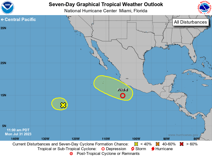
Tropical Weather Outlook
NWS National Hurricane Center Miami FL
1100 AM PDT Mon Jul 31 2023
For the eastern North Pacific...east of 140 degrees west longitude:
1. Offshore of Southern Mexico (EP96):
Showers and thunderstorms are gradually becoming better organized in
association with an area of low pressure located a couple hundred
miles to the south of the southern coast of Mexico. In addition,
recent satellite wind data indicate its circulation is also becoming
better defined. If these trends continue, a tropical depression
could form as soon as later this afternoon. The system is forecast
to move generally westward near 15 mph over the next few days,
moving farther away from the Mexican coast. Additional information
on this system, including gale warnings, can be found in High Seas
Forecasts issued by the National Weather Service.
* Formation chance through 48 hours...high...90 percent.
* Formation chance through 7 days...high...90 percent.
2. Central East Pacific:
A small area of low pressure located about 1100 miles southwest of
the southern tip of the Baja California Peninsula continues to
produce an area of disorganized showers and thunderstorms. The
proximity of nearby dry air is likely to prevent significant
development of this system while it moves westward at 5 to 10 mph
during the next couple of days.
* Formation chance through 48 hours...low...10 percent.
* Formation chance through 7 days...low...10 percent.
3. South of Southwestern Mexico:
An area of low pressure could form towards the end of this week a
few hundred miles south of the coast of southwestern Mexico. Some
gradual development of this system is possible by the weekend while
it moves west-northwestward or northwestward, roughly parallel to
the southwestern coast of Mexico.
* Formation chance through 48 hours...low...near 0 percent.
* Formation chance through 7 days...low...30 percent.
High Seas Forecasts issued by the National Weather Service
can be found under AWIPS header NFDHSFEPI, WMO header FZPN02
KWBC, and on the web at ocean.weather.gov/shtml/NFDHSFEPI.php
Forecaster Papin