ZCZC MIATWOEP ALL
TTAA00 KNHC DDHHMM
Tropical Weather Outlook
NWS National Hurricane Center Miami FL
500 AM PDT Fri Aug 11 2023
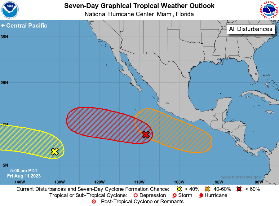
For the eastern North Pacific...east of 140 degrees west longitude:
1. Central East Pacific (EP98):
A broad area of low pressure located several hundred miles southwest
of Manzanillo, Mexico, continues to produce disorganized showers and
a few thunderstorms. Environmental conditions are conducive for
gradual development of this system, and a tropical depression is
likely to form late this weekend or early next week while it moves
westward or northwestward at about 10 mph across the central portion
of the basin.
* Formation chance through 48 hours...medium...40 percent.
* Formation chance through 7 days...high...80 percent.
2. Western East Pacific:
Another tropical wave located well to the southwest of the southern
tip of the Baja California peninsula is producing a large area
of disorganized showers and thunderstorms. Some slow development
of this system is possible during the next several days while it
moves westward to west-northwestward at about 10 mph across the far
western portion of the basin, crossing into the Central Pacific
basin on Sunday.
* Formation chance through 48 hours...low...10 percent.
* Formation chance through 7 days...low...30 percent.
3. Off the Coast of Southern Mexico:
An area of low pressure is forecast to form offshore of Central
America in a few days. Environmental conditions are expected to be
conducive for gradual development of this system, and a tropical
depression could form during the early or middle part of next week
while it moves generally west-northwestward, roughly parallel to the
coast of southern Mexico.
* Formation chance through 48 hours...low...near 0 percent.
* Formation chance through 7 days...medium...60 percent.
Forecaster Berg