


NHC Graphical Outlook Archive
|
« Earliest Available ‹ Earlier Later › Latest Available » |
GIS Shapefiles |
| Eastern North Pacific | Atlantic |
|
Tropical Weather Outlook Text
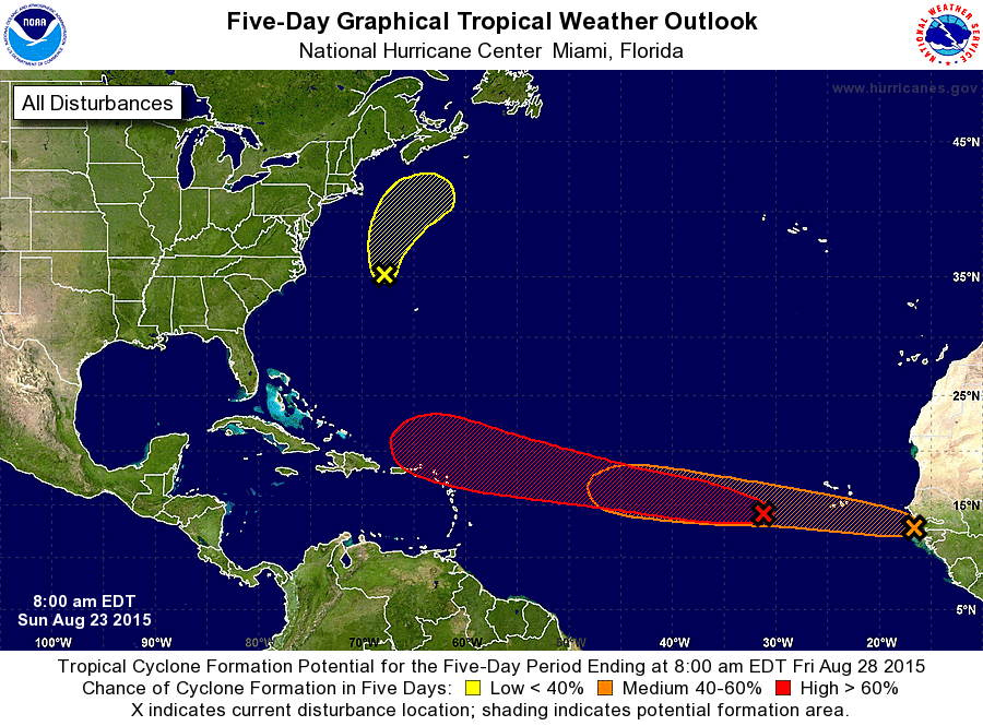
ZCZC MIATWOAT ALL
TTAA00 KNHC DDHHMM

TROPICAL WEATHER OUTLOOK
NWS NATIONAL HURRICANE CENTER MIAMI FL
800 AM EDT SUN AUG 23 2015

For the North Atlantic...Caribbean Sea and the Gulf of Mexico:

The National Hurricane Center is issuing advisories on Tropical
Storm Danny, located a few hundred miles east of the Leeward
Islands.

1. A broad low pressure area located a couple of hundred miles
northwest of Bermuda continues to produce disorganized shower
activity. This system is expected to move generally northward and
merge with a frontal system during the next day or so, and
subtropical or tropical cyclone development is not expected.
* Formation chance through 48 hours...low...near 0 percent
* Formation chance through 5 days...low...near 0 percent

2. Disorganized showers and thunderstorms are associated with a low
pressure area located about 500 miles west of the Cape Verde
Islands. Environmental conditions are expected to be conducive for
development, and a tropical depression is likely to form by
mid-week while the wave moves quickly westward at around 20 mph. By
late this week, atmospheric conditions could become less favorable
for tropical cyclone formation.
* Formation chance through 48 hours...medium...50 percent
* Formation chance through 5 days...high...70 percent

3. Another tropical wave is expected to move off of the west coast of
Africa later today. Environmental conditions could be conducive for
some development of this system this week while this disturbance
moves westward over the eastern tropical Atlantic Ocean at 15 to 20
mph.
* Formation chance through 48 hours...low...10 percent
* Formation chance through 5 days...medium...40 percent

Forecaster Kimberlain
List of Atlantic Outlooks (May 2023 - present)
List of East Pacific Outlooks (May 2023 - present)
List of Central Pacific Outlooks (May 2023 - present)
List of Atlantic Outlooks (July 2014 - April 2023)
List of East Pacific Outlooks (July 2014 - April 2023)
List of Central Pacific Outlooks (June 2019 - April 2023)
List of Atlantic Outlooks (June 2009 - June 2014)
List of East Pacific Outlooks (June 2009 - June 2014)