ZCZC HFOTWOCP ALL
TTAA00 PHFO DDHHMM
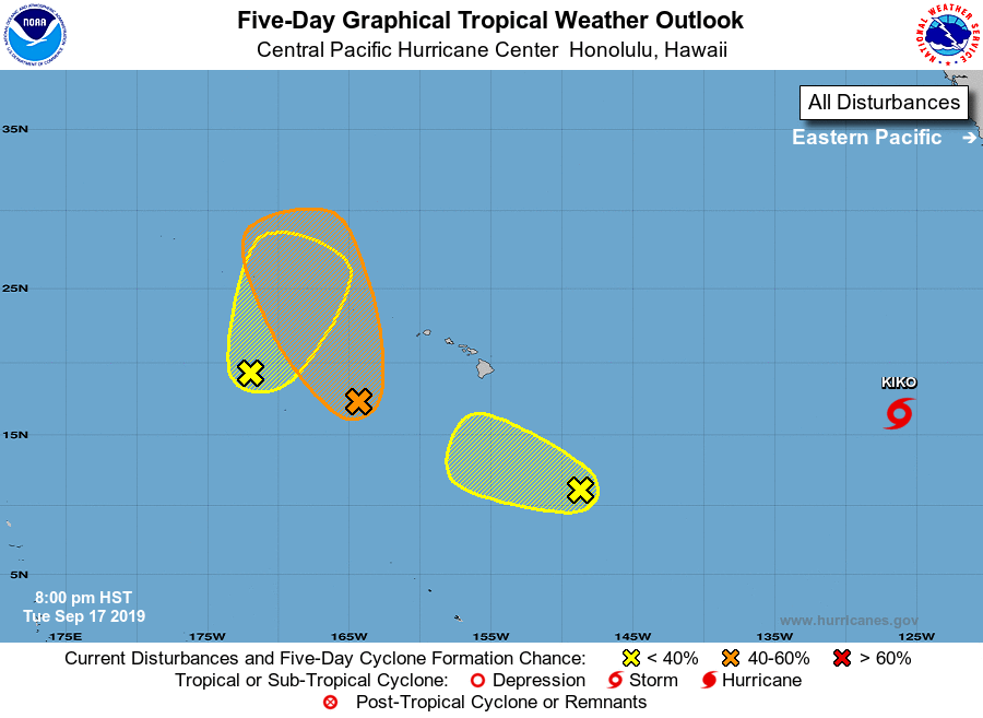
Tropical Weather Outlook
NWS Central Pacific Hurricane Center Honolulu HI
800 PM HST Tue Sep 17 2019
For the central North Pacific...between 140W and 180W:
1. Showers and thunderstorms are associated with an area of low
pressure around 500 miles southwest of Honolulu. Environmental
conditions are expected to be marginally conducive for some
development over the next 24 hours as the system moves toward the
north northwest. By late Wednesday or Thursday, chances for
development drop off significantly as the low interacts with another
disturbance approaching from the northwest. Regardless of
development, this system is expected to bring locally gusty winds
and heavy rain to portions of the Papahanaumokuakea Marine National
Monument over the next several
days.
* Formation chance through 48 hours...medium...40 percent.
* Formation chance through 5 days...medium...40 percent.
2. Showers and thunderstorms associated with an elongated area of low
pressure, located about 830 miles west-southwest of Kauai, remain
disorganized. This system is expected to slowly move northeast into
unfavorable environmental conditions. By late Wednesday or Thursday,
chances for development drop off significantly as the low interacts
with another disturbance approaching from the northwest. Regardless
of development, this system is expected to bring locally gusty winds
and heavy rain to portions of the Papahanaumokuakea Marine National
Monument over the next several days.
* Formation chance through 48 hours...low...20 percent.
* Formation chance through 5 days...low...20 percent.
3. An elongated area of low pressure lies around 700 miles southeast of
Hilo, Hawaii. Slow development is possible during the next several
days while the area slowly moves northwestward, though the
environmental conditions are only marginally favorable.
* Formation chance through 48 hours...low...near 0 percent.
* Formation chance through 5 days...low...20 percent.
Elsewhere, no tropical cyclones are expected during the next 5 days.
Forecaster Foster