ZCZC MIATWOEP ALL
TTAA00 KNHC DDHHMM
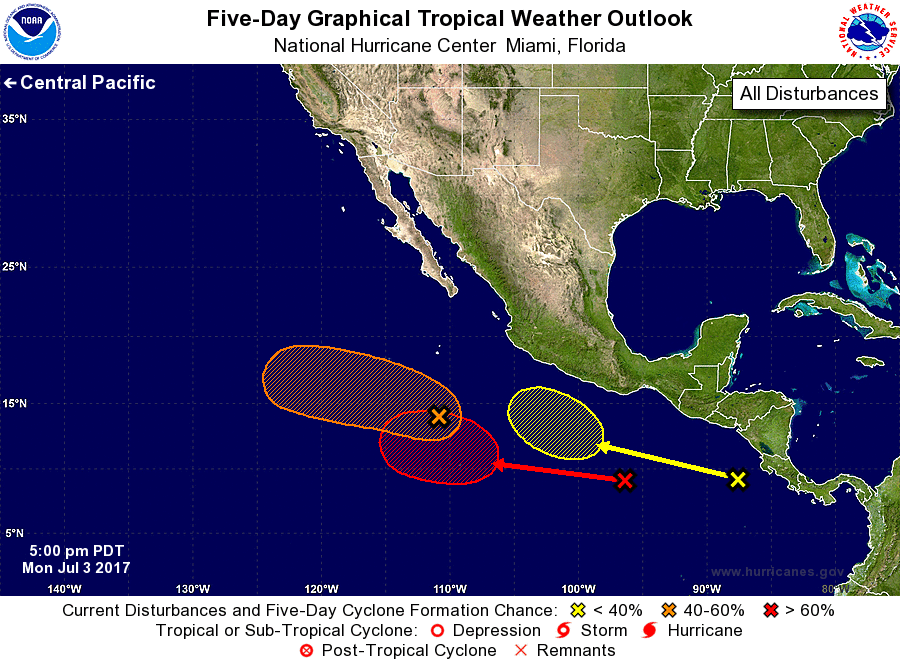
Tropical Weather Outlook
NWS National Hurricane Center Miami FL
500 PM PDT Mon Jul 3 2017
For the eastern North Pacific...east of 140 degrees west longitude:
1. An area of low pressure is located about 625 miles south of the
southern tip of the Baja California peninsula. The low's
circulation is becoming a little better defined, and the associated
shower and thunderstorm activity continues to show signs of
organization. Environmental conditions are conducive for additional
development while the low moves west-northwestward at 10 to 15 mph,
and a tropical depression could form before the system reaches
colder water in a couple of days.
* Formation chance through 48 hours...medium...60 percent.
* Formation chance through 5 days...medium...60 percent.
2. A tropical wave located south-southwest of the Gulf of Tehuantepec
is producing disorganized showers and thunderstorms. A low pressure
system is expected to form well southwest of the coast of Mexico in
association with the wave during the next few days. Environmental
conditions are forecast to be favorable for development, and a
tropical depression is likely to form later this week while the
system moves westward at about 10 mph.
* Formation chance through 48 hours...low...near 0 percent.
* Formation chance through 5 days...high...70 percent.
3. A third area of disturbed weather is located over the far eastern
North Pacific, just offshore the coast of Central America. Some
development of this system is possible late this week while it moves
westward to west-northwestward well south of the coast of Mexico.
* Formation chance through 48 hours...low...near 0 percent.
* Formation chance through 5 days...low...20 percent.
Forecaster Berg