ZCZC MIATWOEP ALL
TTAA00 KNHC DDHHMM
Tropical Weather Outlook
NWS National Hurricane Center Miami FL
1100 PM PDT Wed Jul 28 2021
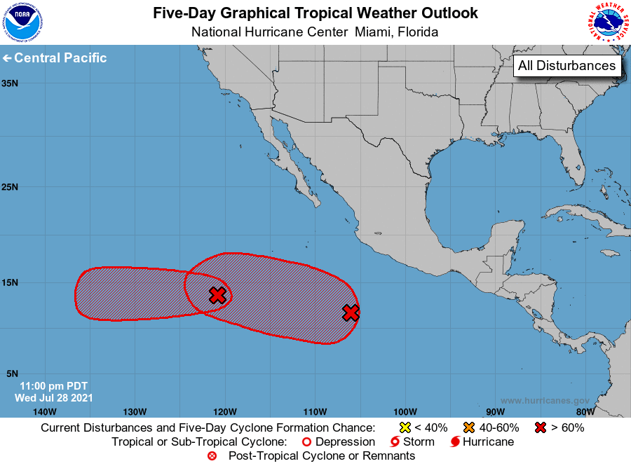
For the eastern North Pacific...east of 140 degrees west longitude:
1. Satellite imagery indicates that shower activity associated with an
area of low pressure located about 900 miles southwest of the
southern tip of the Baja California peninsula is gradually becoming
better organized. Environmental conditions are expected to
gradually become more favorable for development during the next
couple of days, and a tropical depression is likely to form by this
weekend while the system moves generally westward at 5 to 10 mph.
* Formation chance through 48 hours...medium...60 percent.
* Formation chance through 5 days...high...80 percent.
2. Satellite imagery indicates that a broad area of low pressure is
located several hundred miles offshore of the southwestern coast of
Mexico, and that the associated shower activity is showing signs
of organization. Environmental conditions are forecast to be
conducive for continued gradual development, and a tropical
depression is likely to form this weekend or early next week while
the system moves westward or west-northwestward at 10 to 15 mph.
* Formation chance through 48 hours...medium...40 percent.
* Formation chance through 5 days...high...70 percent.
Forecaster Beven