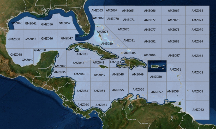
Hover to view popup zone forecast; click a zone to view related text forecast below. Show All Text Below
000
FZNT23 KNHC 230751
OFFNT3

Offshore Waters Forecast for the Caribbean Sea and Tropical
N Atlantic
NWS National Hurricane Center Miami, FL
351 AM EDT Tue Apr 23 2024

Offshore Waters Forecast for Caribbean Sea, and the Tropical N
Atlantic from 07N to 19N W of 55W.

Seas given as significant wave height, which is the average
height of the highest 1/3 of the waves. Individual waves may be
more than twice the significant wave height.
AMZ001-232000-
Synopsis for Caribbean Sea, and Tropical N Atlantic from 07N to
19N W of 55W
351 AM EDT Tue Apr 23 2024

.SYNOPSIS...Broad high pressure north of the area will support
mainly gentle to moderate trades through early Wed, locally fresh
near the Windward Passage and S-central Caribbean. The pressure
gradient will increase through the day Wed, with moderate to
locally fresh trades dominating the basin through the end of the
week and into the weekend. Winds will pulse to fresh to strong in
the S-central Caribbean and near the Windward Passage Wed evening
and night, and in the Lee of Cuba Thu night. Similar winds are
possible S of Hispaniola, near the Windward Passage, in the Lee of
Cuba, and near the Gulf of Honduras Sat night. Slight to moderate
seas will prevail through the next several days.
AMZ040-232000-
Caribbean N of 18N W of 85W including Yucatan Basin-
351 AM EDT Tue Apr 23 2024

.TODAY...NE to E winds 10 to 15 kt. Seas 3 to 5 ft.
.TONIGHT...NE to E winds 10 to 15 kt. Seas 3 to 5 ft.
.WED...E winds 10 to 15 kt. Seas 2 to 4 ft.
.WED NIGHT...NE to E winds 10 to 15 kt. Seas 3 ft or less.
.THU...E winds 10 to 15 kt. Seas 3 ft or less.
.THU NIGHT...E winds 10 to 15 kt. Seas 3 ft or less.
.FRI...E winds 15 kt. Seas 3 to 5 ft.
.FRI NIGHT...E to SE winds 15 to 20 kt. Seas 3 to 5 ft.
.SAT...E to SE winds 15 to 20 kt. Seas 4 to 6 ft.
.SAT NIGHT...E winds 15 to 20 kt. Seas 4 to 6 ft.
Forecaster Lewitsky
AMZ041-232000-
Caribbean N of 20N E of 85W-
351 AM EDT Tue Apr 23 2024

.TODAY...NE to E winds 10 to 15 kt. Seas 2 to 4 ft.
.TONIGHT...W of 81W, NE winds 10 to 15 kt. E of 81W, NW to N
winds 10 to 15 kt, becoming NE to E 15 to 20 kt late. Seas 2 to 4
ft.

.WED...E winds 10 to 15 kt. Seas 2 to 4 ft.
.WED NIGHT...W of 81W, NE winds 10 to 15 kt. E of 81W, N winds
10 kt, becoming NE to E 15 to 20 kt late. Seas 2 to 4 ft.
.THU...NE to E winds 10 to 15 kt W of 81W, and NE to E 15 to
20 kt E of 81W. Seas 2 to 4 ft.
.THU NIGHT...NE to E winds 10 kt, increasing to 15 to 20 kt late.
Seas 2 to 4 ft.
.FRI...E winds 15 to 20 kt. Seas 3 to 5 ft.
.FRI NIGHT...E winds 15 to 20 kt W of 81W, and NE to E 15 to
20 kt E of 81W. Seas 3 to 5 ft.
.SAT...Winds E winds 15 to 20 kt. Seas 4 to 6 ft.
.SAT NIGHT...E winds 15 to 20 kt W of 81W, and NE to E 15 to
20 kt E of 81W. Seas 4 to 6 ft.
Forecaster Lewitsky
AMZ042-232000-
Caribbean from 18N to 20N between 80W and 85W including Cayman
Basin-
351 AM EDT Tue Apr 23 2024

.TODAY...NE to E winds 10 to 15 kt. Seas 3 ft or less, building
to 2 to 4 ft in the afternoon.
.TONIGHT...NE winds 10 to 15 kt. Seas 2 to 4 ft.
.WED...NE to E winds 10 to 15 kt. Seas 2 to 4 ft.
.WED NIGHT...NE winds 10 to 15 kt. Seas 2 to 4 ft.
.THU...NE to E winds 10 to 15 kt. Seas 2 to 4 ft.
.THU NIGHT...NE to E winds 10 to 15 kt. Seas 2 to 4 ft.
.FRI...NE to E winds 15 to 20 kt. Seas 3 to 5 ft.
.FRI NIGHT...E winds 10 to 15 kt. Seas 3 to 5 ft.
.SAT...E winds 15 to 20 kt. Seas 3 to 5 ft.
.SAT NIGHT...E winds 10 to 15 kt. Seas 4 to 6 ft.
Forecaster Lewitsky
AMZ043-232000-
Caribbean from 18N to 20N between 76W and 80W-
351 AM EDT Tue Apr 23 2024

.TODAY...W of 78W, NE winds 10 to 15 kt. E of 78W, variable winds
less than 5 kt, becoming E 10 kt in the afternoon. Seas 3 ft or
less.
.TONIGHT...W of 78W, N to NE winds 10 kt, becoming NE 15 to 20 kt
late. E of 78W, variable winds less than 5 kt, becoming NE to E
10 kt late. Seas 3 ft or less.
.WED...NE to E winds 15 to 20 kt W of 78W, and E 10 to 15 kt E of
78W. Seas 3 to 5 ft.
.WED NIGHT...NE to E winds 10 to 15 kt. Seas 3 to 5 ft.
.THU...NE to E winds 15 to 20 kt W of 78W, and NE to E 10 to
15 kt E of 78W. Seas 3 to 5 ft.
.THU NIGHT...W of 78W, NE winds 10 kt, increasing to 15 to 20 kt
late. E of 78W, NE to E winds 10 to 15 kt. Seas 3 to
5 ft.
.FRI...NE to E winds 15 to 20 kt W of 78W, and E 10 to 15 kt E of
78W. Seas 3 to 5 ft.
.FRI NIGHT...NE to E winds 15 to 20 kt W of 78W, and E 10 to
15 kt E of 78W. Seas 3 to 5 ft.
.SAT...NE to E winds 15 to 20 kt W of 78W, and E 10 to 15 kt E of
78W. Seas 3 to 5 ft.
.SAT NIGHT...E winds 15 to 20 kt. Seas 5 to 7 ft.
Forecaster Lewitsky
AMZ044-232000-
Caribbean approaches to the Windward Passage-
351 AM EDT Tue Apr 23 2024

.TODAY...In the Gulf of Gonave, variable winds less than 5 kt,
becoming NW to N 10 kt in the afternoon. Elsewhere, NE winds
10 to 15 kt. Seas 3 ft or less.
.TONIGHT...N to NE winds 15 to 20 kt in the Gulf of Gonave, and
NE 15 to 20 kt elsewhere. Seas 3 to 5 ft.
.WED...In the Gulf of Gonave, NE winds 10 kt, shifting to NW to N
in the afternoon. Elsewhere, NE winds 15 to 20 kt. Seas 3 to
5 ft.
.WED NIGHT...NE winds 10 to 15 kt in the Gulf of Gonave, and NE
15 to 20 kt elsewhere. Seas 4 to 6 ft.
.THU...In the Gulf of Gonave, NE winds 10 kt, shifting to NW to N
in the afternoon. Elsewhere, NE winds 15 to 20 kt. Seas 3 ft or
less in the Gulf of Gonave, and 4 to 6 ft elsewhere.
.THU NIGHT...In the Gulf of Gonave, N to NE winds 15 to 20 kt,
becoming NE to E 10 kt late. Elsewhere, NE winds 15 to 20 kt.
Seas 3 to 5 ft.
.FRI...In the Gulf of Gonave, variable winds less than 5 kt,
becoming N 10 kt in the afternoon. Elsewhere, NE to E winds 10 to
15 kt. Seas 3 to 5 ft.
.FRI NIGHT...NE winds 10 kt in the Gulf of Gonave, and NE 15 to
20 kt elsewhere. Seas 3 to 5 ft.
.SAT...In the Gulf of Gonave, variable winds less than 5 kt,
becoming NW to N 10 kt in the afternoon. Elsewhere, NE to E winds
15 to 20 kt. Seas 3 to 5 ft.
.SAT NIGHT...NE winds 10 kt in the Gulf of Gonave, and NE to E
15 to 20 kt elsewhere. Seas 5 to 7 ft in NE swell.
Forecaster Lewitsky
AMZ045-232000-
S of 18N W of 85W including Gulf of Honduras-
351 AM EDT Tue Apr 23 2024

.TODAY...NE to E winds 10 kt. Seas 3 ft or less.
.TONIGHT...NE to E winds 10 to 15 kt. Seas 3 ft or less.
.WED...NE to E winds 10 to 15 kt. Seas 2 to 4 ft.
.WED NIGHT...NE to E winds 10 to 15 kt. Seas 2 to 4 ft.
.THU...E winds 10 to 15 kt. Seas 2 to 4 ft.
.THU NIGHT...E winds 10 to 15 kt. Seas 2 to 4 ft.
.FRI...E winds 10 to 15 kt. Seas 2 to 4 ft.
.FRI NIGHT...E winds 15 to 20 kt. Seas 3 to 5 ft.
.SAT...E winds 15 to 20 kt. Seas 4 to 6 ft.
.SAT NIGHT...E winds 20 to 25 kt. Seas 5 to 7 ft.
Forecaster Lewitsky
AMZ046-232000-
Caribbean from 15N to 18N between 80W and 85W-
351 AM EDT Tue Apr 23 2024

.TODAY...NE to E winds 10 to 15 kt. Seas 3 ft or less.
.TONIGHT...NE to E winds 10 to 15 kt. Seas 2 to 4 ft.
.WED...NE to E winds 10 to 15 kt. Seas 2 to 4 ft.
.WED NIGHT...NE winds 10 to 15 kt. Seas 3 to 5 ft.
.THU...NE winds 10 to 15 kt. Seas 2 to 4 ft W of 82W, and 3 to
5 ft E of 82W.
.THU NIGHT...NE to E winds 10 to 15 kt. Seas 2 to 4 ft W of 82W,
and 3 to 5 ft E of 82W.
.FRI...NE to E winds 10 to 15 kt. Seas 2 to 4 ft.
.FRI NIGHT...E winds 10 to 15 kt. Seas 2 to 4 ft W of 82W, and
3 to 5 ft E of 82W.
.SAT...E winds 10 to 15 kt. Seas 2 to 4 ft W of 82W, and 3 to
5 ft E of 82W.
.SAT NIGHT...E winds 15 to 20 kt W of 82W, and E 10 to 15 kt E of
82W. Seas 3 to 5 ft.
Forecaster Lewitsky
AMZ047-232000-
Caribbean from 15N to 18N between 76W and 80W-
351 AM EDT Tue Apr 23 2024

.TODAY...NE to E winds 10 to 15 kt. Seas 2 to 4 ft.
.TONIGHT...NE winds 10 to 15 kt. Seas 2 to 4 ft.
.WED...NE to E winds 15 to 20 kt. Seas 3 to 5 ft.
.WED NIGHT...NE winds 10 to 15 kt. Seas 2 to 4 ft.
.THU...NE to E winds 10 to 15 kt. Seas 3 to 5 ft.
.THU NIGHT...NE to E winds 10 to 15 kt. Seas 3 to 5 ft.
.FRI...NE to E winds 10 to 15 kt. Seas 3 to 5 ft.
.FRI NIGHT...NE to E winds 10 to 15 kt. Seas 3 to 5 ft.
.SAT...E winds 10 to 15 kt. Seas 3 to 5 ft.
.SAT NIGHT...E winds 10 to 15 kt. Seas 4 to 6 ft.
Forecaster Lewitsky
AMZ048-232000-
Caribbean from 15N to 18N between 72W and 76W-
351 AM EDT Tue Apr 23 2024

.TODAY...NE to E winds 10 to 15 kt. Seas 2 to 4 ft.
.TONIGHT...NE to E winds 10 to 15 kt. Seas 2 to 4 ft.
.WED...E winds 10 to 15 kt. Seas 3 to 5 ft.
.WED NIGHT...NE to E winds 10 to 15 kt. Seas 2 to 4 ft.
Scattered showers.
.THU...NE to E winds 10 to 15 kt. Seas 3 to 5 ft.
.THU NIGHT...NE to E winds 10 to 15 kt. Seas 3 to 5 ft.
.FRI...E winds 10 to 15 kt. Seas 3 to 5 ft.
.FRI NIGHT...NE to E winds 10 to 15 kt. Seas 3 to 5 ft.
.SAT...E winds 10 to 15 kt. Seas 3 to 5 ft.
.SAT NIGHT...E winds 15 to 20 kt. Seas 4 to 6 ft.
Forecaster Lewitsky
AMZ049-232000-
Caribbean N of 15N between 68W and 72W-
351 AM EDT Tue Apr 23 2024

.TODAY...E winds 10 kt. Seas 2 to 4 ft.
.TONIGHT...E winds 10 kt. Seas 2 to 4 ft.
.WED...NE to E winds 10 to 15 kt. Seas 2 to 4 ft.
.WED NIGHT...E winds 10 to 15 kt. Seas 3 to 5 ft.
Scattered showers.
.THU...E winds 10 to 15 kt. Seas 3 to 5 ft.
.THU NIGHT...E winds 10 to 15 kt. Seas 3 to 5 ft.
.FRI...E winds 10 to 15 kt. Seas 3 to 5 ft.
.FRI NIGHT...NE to E winds 15 to 20 kt W of 70W, and NE to E
10 to 15 kt E of 70W. Seas 3 to 5 ft.
.SAT...NE to E winds 15 to 20 kt W of 70W, and NE to E 10 to
15 kt E of 70W. Seas 3 to 5 ft.
.SAT NIGHT...NE to E winds 15 to 20 kt. Seas 4 to 6 ft.
Forecaster Lewitsky
AMZ050-232000-
Caribbean N of 15N between 64W and 68W-
351 AM EDT Tue Apr 23 2024

.TODAY...E to SE winds 10 to 15 kt. Seas 2 to 4 ft.
.TONIGHT...E winds 10 to 15 kt. Seas 2 to 4 ft.
Scattered showers.
.WED...E to SE winds 10 to 15 kt. Seas 2 to 4 ft.
.WED NIGHT...E winds 10 to 15 kt. Seas 2 to 4 ft.
Scattered showers.
.THU...E winds 15 kt. Seas 3 to 5 ft.
.THU NIGHT...E winds 15 kt. Seas 3 to 5 ft.
.FRI...E winds 10 to 15 kt. Seas 3 to 5 ft.
.FRI NIGHT...NE to E winds 15 kt. Seas 3 to 5 ft.
.SAT...NE to E winds 10 to 15 kt. Seas 3 to 5 ft.
.SAT NIGHT...NE to E winds 15 kt. Seas 3 to 5 ft.
Forecaster Lewitsky
AMZ051-232000-
Offshore Waters Leeward Islands-
351 AM EDT Tue Apr 23 2024

.TODAY...E to SE winds 10 to 15 kt. Seas 4 to 6 ft.
.TONIGHT...E winds 10 to 15 kt. Seas 4 to 6 ft.
Scattered showers.
.WED...E to SE winds 10 to 15 kt in the Caribbean, and
E 15 to 20 kt in the Atlc. Seas 4 to 6 ft. Scattered showers.
.WED NIGHT...E winds 10 to 15 kt. Seas 4 to 6 ft.
.THU...E winds 10 to 15 kt. Seas 4 to 6 ft.
.THU NIGHT...E winds 10 to 15 kt. Seas 4 to 6 ft.
.FRI...E winds 10 to 15 kt. Seas 4 to 6 ft.
.FRI NIGHT...NE to E winds 10 to 15 kt. Seas 4 to 6 ft.
.SAT...NE to E winds 10 kt. Seas 4 to 6 ft in NE swell.
.SAT NIGHT...NE winds 10 to 15 kt. Seas 3 to 5 ft.
Forecaster Lewitsky
AMZ052-232000-
Tropical N Atlantic from 15N to 19N between 55W and 60W-
351 AM EDT Tue Apr 23 2024

.TODAY...E winds 15 to 20 kt. Seas 5 to 7 ft.
.TONIGHT...NE to E winds 15 to 20 kt. Seas 5 to 7 ft.
.WED...NE to E winds 15 to 20 kt. Seas 5 to 7 ft.
.WED NIGHT...NE to E winds 15 kt. Seas 4 to 6 ft.
.THU...E winds 15 kt. Seas 4 to 6 ft.
.THU NIGHT...E winds 10 to 15 kt. Seas 4 to 6 ft.
.FRI...NE to E winds 10 to 15 kt. Seas 4 to 6 ft.
.FRI NIGHT...NE to E winds 10 to 15 kt. Seas 4 to 6 ft.
.SAT...S of 17N, E winds 10 kt in the morning, becoming variable
less than 5 kt. N of 17N, NE to E winds 10 kt. Seas 4 to 6 ft.
.SAT NIGHT...NE to E winds 10 kt. Seas 3 to 5 ft.
Forecaster Lewitsky
AMZ053-232000-
W Central Caribbean from 11N to 15N W of 80W-
351 AM EDT Tue Apr 23 2024

.TODAY...NE to E winds 10 to 15 kt. Seas 2 to 4 ft.
Scattered showers.
.TONIGHT...NE winds 10 to 15 kt. Seas 3 to 5 ft.
.WED...NE winds 10 to 15 kt. Seas 3 to 5 ft. Scattered showers.
.WED NIGHT...NE winds 10 to 15 kt. Seas 3 to 5 ft.
Scattered showers.
.THU...NE winds 10 to 15 kt. Seas 3 to 5 ft.
.THU NIGHT...NE winds 10 to 15 kt. Seas 3 to 5 ft.
.FRI...NE winds 10 to 15 kt. Seas 3 to 5 ft.
.FRI NIGHT...NE to E winds 10 to 15 kt. Seas 3 to 5 ft.
.SAT...NE to E winds 10 to 15 kt. Seas 3 to 5 ft.
.SAT NIGHT...NE to E winds 10 to 15 kt. Seas 3 to 5 ft.
Forecaster Lewitsky
AMZ054-232000-
Caribbean from 11N to 15N between 76W and 80W-
351 AM EDT Tue Apr 23 2024

.TODAY...NE to E winds 10 to 15 kt. Seas 3 to 5 ft.
.TONIGHT...NE winds 15 kt. Seas 3 to 5 ft.
.WED...NE to E winds 15 to 20 kt. Seas 4 to 6 ft.
.WED NIGHT...NE winds 15 to 20 kt. Seas 4 to 6 ft.
.THU...NE to E winds 15 to 20 kt. Seas 6 to 8 ft in E swell.
.THU NIGHT...NE to E winds 10 to 15 kt. Seas 5 to 7 ft in E
swell.
.FRI...NE to E winds 10 to 15 kt. Seas 4 to 6 ft.
.FRI NIGHT...NE to E winds 10 to 15 kt. Seas 3 to 5 ft.
.SAT...NE to E winds 15 kt. Seas 3 to 5 ft.
.SAT NIGHT...NE to E winds 15 kt. Seas 3 to 5 ft.
Forecaster Lewitsky
AMZ055-232000-
Caribbean from 11N to 15N between 72W and 76W including Colombia
Basin-
351 AM EDT Tue Apr 23 2024

.TODAY...NE to E winds 10 to 15 kt. Seas 3 to 5 ft.
.TONIGHT...NE to E winds 15 to 20 kt. Seas 3 to 5 ft.
.WED...NE to E winds 15 to 20 kt. Seas 4 to 6 ft.
.WED NIGHT...NE to E winds 20 to 25 kt S of 13N, and NE to E
15 to 20 kt N of 13N. Seas 5 to 7 ft.
.THU...S of 13N, NE to E winds 20 to 25 kt, becoming E 10 to
15 kt in the afternoon. N of 13N, NE to E winds 15 kt.
Seas 6 to 8 ft.
.THU NIGHT...NE to E winds 10 to 15 kt. Seas 4 to 6 ft.
.FRI...NE to E winds 10 to 15 kt. Seas 3 to 5 ft.
.FRI NIGHT...NE to E winds 15 kt. Seas 3 to 5 ft.
.SAT...NE to E winds 15 kt. Seas 3 to 5 ft.
.SAT NIGHT...NE to E winds 15 kt. Seas 3 to 5 ft.
Forecaster Lewitsky
AMZ056-232000-
Caribbean S of 15N between 68W and 72W including Gulf of
Venezuela-
351 AM EDT Tue Apr 23 2024

.TODAY...E winds 10 to 15 kt. Seas 3 to 5 ft.
.TONIGHT...NE to E winds 10 to 15 kt. Seas 3 to 5 ft.
.WED...E winds 15 kt. Seas 2 to 4 ft.
.WED NIGHT...E winds 15 to 20 kt. Seas 3 to 5 ft.
.THU...E winds 15 kt. Seas 3 to 5 ft.
.THU NIGHT...E winds 15 kt. Seas 3 to 5 ft.
.FRI...E winds 10 to 15 kt. Seas 3 to 5 ft.
.FRI NIGHT...E winds 10 to 15 kt. Seas 3 to 5 ft.
.SAT...NE to E winds 10 to 15 kt. Seas 3 to 5 ft.
.SAT NIGHT...NE to E winds 10 to 15 kt. Seas 3 to 5 ft.
Forecaster Lewitsky
AMZ057-232000-
Caribbean S of 15N between 64W and 68W including Venezuela Basin-
351 AM EDT Tue Apr 23 2024

.TODAY...E winds 10 to 15 kt. Seas 3 to 5 ft.
.TONIGHT...NE to E winds 15 to 20 kt S of 13N, and E 10 to 15 kt
N of 13N. Seas 3 to 5 ft.
.WED...E winds 10 to 15 kt. Seas 3 to 5 ft.
.WED NIGHT...E winds 15 to 20 kt. Seas 3 to 5 ft.
.THU...E winds 10 to 15 kt. Seas 3 to 5 ft.
.THU NIGHT...E winds 15 kt. Seas 3 to 5 ft.
.FRI...E winds 10 to 15 kt. Seas 3 to 5 ft.
.FRI NIGHT...NE to E winds 10 to 15 kt. Seas 3 to 5 ft.
.SAT...E winds 10 to 15 kt. Seas 3 to 5 ft.
.SAT NIGHT...NE to E winds 10 to 15 kt. Seas 3 to 5 ft.
Forecaster Lewitsky
AMZ058-232000-
Offshore Waters Windward Islands including Trinidad and Tobago-
351 AM EDT Tue Apr 23 2024

.TODAY...E winds 10 to 15 kt. Seas 4 to 6 ft.
.TONIGHT...E winds 15 to 20 kt in the Caribbean, and E 10 to
15 kt in the Atlc. Seas 4 to 6 ft.
.WED...E winds 10 to 15 kt. Seas 4 to 6 ft.
.WED NIGHT...E winds 15 to 20 kt in the Caribbean, and E 10 to
15 kt in the Atlc. Seas 4 to 6 ft.
.THU...E winds 10 to 15 kt. Seas 4 to 6 ft.
.THU NIGHT...NE to E winds 10 to 15 kt. Seas 3 to 5 ft.
.FRI...E winds 10 to 15 kt. Seas 4 to 6 ft.
.FRI NIGHT...E winds 10 to 15 kt. Seas 4 to 6 ft.
.SAT...E winds 10 to 15 kt. Seas 4 to 6 ft.
.SAT NIGHT...NE to E winds 10 to 15 kt. Seas 3 to 5 ft.
Forecaster Lewitsky
AMZ059-232000-
Tropical N Atlantic from 11N and 15N between 55W and 60W-
351 AM EDT Tue Apr 23 2024

.TODAY...E winds 15 kt. Seas 4 to 6 ft.
.TONIGHT...E winds 15 kt. Seas 4 to 6 ft.
.WED...E winds 10 to 15 kt. Seas 4 to 6 ft.
.WED NIGHT...NE to E winds 10 to 15 kt. Seas 4 to 6 ft.
Scattered showers.
.THU...NE to E winds 10 to 15 kt. Seas 4 to 6 ft.
.THU NIGHT...E winds 15 kt. Seas 4 to 6 ft.
.FRI...NE to E winds 10 to 15 kt. Seas 4 to 6 ft.
.FRI NIGHT...NE to E winds 10 to 15 kt. Seas 4 to 6 ft.
.SAT...E winds 10 kt. Seas 4 to 6 ft in NE swell.
.SAT NIGHT...NE to E winds 10 kt. Seas 4 to 6 ft in NE swell.
Forecaster Lewitsky
AMZ060-232000-
SW Caribbean S of 11N W of 80W-
351 AM EDT Tue Apr 23 2024

.TODAY...NE winds 10 to 15 kt. Seas 2 to 4 ft. Scattered showers.
.TONIGHT...NE winds 10 to 15 kt. Seas 3 to 5 ft.
Scattered showers and isolated tstms.
.WED...NE winds 10 to 15 kt. Seas 3 to 5 ft. Scattered showers
and isolated tstms.
.WED NIGHT...N to NE winds 10 to 15 kt. Seas 3 to 5 ft.
Scattered showers and isolated tstms.
.THU...N to NE winds 10 to 15 kt. Seas 3 to 5 ft.
.THU NIGHT...N to NE winds 10 to 15 kt. Seas 3 to 5 ft.
.FRI...N to NE winds 10 kt. Seas 3 to 5 ft.
.FRI NIGHT...S of 10N, N to NE winds 10 kt. N of 10N, NE winds
10 kt in the evening, becoming variable less than 5 kt. Seas 3 to
5 ft.
.SAT...Variable winds less than 5 kt, becoming NE 10 kt in the
afternoon. Seas 2 to 4 ft.
.SAT NIGHT...S of 10N, NE winds 10 kt in the evening, becoming
variable less than 5 kt. N of 10N, NE to E winds 10 kt. Seas 2 to
4 ft.
Forecaster Lewitsky
AMZ061-232000-
SW Caribbean S of 11N E of 80W including the approaches to the
Panama Canal-
351 AM EDT Tue Apr 23 2024

.TODAY...NE to E winds 10 to 15 kt. Seas 3 to 5 ft.
Scattered showers.
.TONIGHT...NE winds 10 to 15 kt S of 10N, and NE 15 to 20 kt N of
10N. Seas 3 to 5 ft. Scattered showers.
.WED...NE winds 10 to 15 kt S of 10N, and NE 15 to 20 kt N of
10N. Seas 4 to 6 ft. Scattered tstms.
.WED NIGHT...N to NE winds 15 to 20 kt. Seas 4 to 6 ft.
Scattered tstms.
.THU...S of 10N, NE winds 10 to 15 kt, shifting to S in the
afternoon. N of 10N, NE to E winds 15 to 20 kt. Seas 6 to 8 ft.
.THU NIGHT...S of 10N, SW to W winds 10 kt, shifting to E late. N
of 10N, E winds 15 to 20 kt. Seas 5 to 7 ft.
.FRI...NE to E winds 10 kt. Seas 4 to 6 ft in NE swell.
.FRI NIGHT...NE winds 10 to 15 kt. Seas 3 to 5 ft.
.SAT...NE to E winds 10 kt. Seas 3 to 5 ft.
.SAT NIGHT...S of 10N, variable winds less than 5 kt, becoming
NE 10 kt late. N of 10N, NE to E winds 10 to 15 kt. Seas 3 to 5
ft.
Forecaster Lewitsky
AMZ062-232000-
Tropical N Atlantic from 7N and 11N between 55W and 60W-
351 AM EDT Tue Apr 23 2024

.TODAY...NE to E winds 15 to 20 kt. Seas 4 to 6 ft.
.TONIGHT...NE to E winds 15 kt. Seas 4 to 6 ft.
.WED...NE to E winds 10 to 15 kt. Seas 4 to 6 ft.
.WED NIGHT...NE to E winds 10 to 15 kt. Seas 4 to 6 ft.
.THU...E winds 10 to 15 kt. Seas 4 to 6 ft.
.THU NIGHT...NE to E winds 10 to 15 kt. Seas 4 to 6 ft.
.FRI...NE to E winds 10 to 15 kt. Seas 4 to 6 ft.
.FRI NIGHT...NE to E winds 10 to 15 kt. Seas 4 to 6 ft.
.SAT...NE to E winds 10 kt. Seas 4 to 6 ft in NE swell.
.SAT NIGHT...NE to E winds 10 kt. Seas 4 to 6 ft in NE swell.
Forecaster Lewitsky
000
FZNT25 KNHC 230758
OFFNT5

Offshore Waters Forecast for SW N Atlantic including the Bahamas
NWS National Hurricane Center Miami, FL
358 AM EDT Tue Apr 23 2024

Offshore Waters Forecast for the SW N Atlantic from 19N to 31N W
of 55W including Bahamas.

Seas given as significant wave height, which is the average
height of the highest 1/3 of the waves. Individual waves may be
more than twice the significant wave height.
AMZ101-232000-
Synopsis for the SW N Atlantic including the Bahamas
358 AM EDT Tue Apr 23 2024

.SYNOPSIS...A cold front extends from 31N70W to the Straits of
Florida. A line of showers and thunderstorms is observed within
120 nm ahead of the frontal boundary, mainly N of 27N. Associated
fresh to strong winds N of 29N on either side of the front will
lift N of the area by the afternoon. Associated seas of 8 ft or
greater behind the front will subside by Wed evening. The front
will reach from 31N64W to the SE Bahamas this evening while
weakening, then will become a dissipating stationary front from
31N59W to 21N76W Wed evening, then becoming a remnant trough
there by Thu evening. The trough will linger through the end of
the week, getting reinforced by a cold front which may dive S of
31N Fri night, reaching from 31N54W to near N Haiti by Sat
evening. Increasing winds to fresh to strong W of the boundary
will prevail by Sat evening along with a rapidly building area of
large seas.
AMZ063-232000-
Atlantic from 29N to 31N W of 77W-
358 AM EDT Tue Apr 23 2024

.TODAY...NE winds 10 to 15 kt. Seas 6 to 9 ft.
.TONIGHT...NE to E winds 10 kt, shifting to SE late.
Seas 4 to 6 ft.
.WED...Variable winds less than 5 kt, becoming S to SW 10 kt in
the afternoon. Seas 3 to 5 ft.
.WED NIGHT...S winds 10 kt. Seas 3 to 5 ft.
.THU...S to SW winds 10 kt. Seas 2 to 4 ft.
.THU NIGHT...E to SE winds 10 kt. Seas 2 to 4 ft.
.FRI...E winds 10 to 15 kt. Seas 2 to 4 ft.
.FRI NIGHT...E winds 10 to 15 kt. Seas 2 to 4 ft.
.SAT...E winds 15 kt. Seas 3 to 5 ft.
.SAT NIGHT...E winds 15 to 20 kt. Seas 4 to 6 ft.
Forecaster Lewitsky
AMZ064-232000-
Atlantic from 29N to 31N between 74W and 77W-
358 AM EDT Tue Apr 23 2024

.TODAY...N winds 15 to 20 kt. Seas 7 to 10 ft.
.TONIGHT...N to NE winds 10 kt in the evening, becoming variable
less than 5 kt. Seas 6 to 8 ft.
.WED...Variable winds less than 5 kt. Seas 4 to 6 ft.
.WED NIGHT...Variable winds less than 5 kt. Seas 3 to 5 ft.
.THU...S winds 10 kt. Seas 2 to 4 ft.
.THU NIGHT...SW winds 10 kt. Seas 2 to 4 ft.
.FRI...NE to E winds 10 kt. Seas 2 to 4 ft.
.FRI NIGHT...NE to E winds 10 to 15 kt. Seas 3 to 5 ft.
.SAT...NE to E winds 15 to 20 kt. Seas 4 to 6 ft.
.SAT NIGHT...E winds 15 to 20 kt. Seas 5 to 7 ft.
Forecaster Lewitsky
AMZ065-232000-
Atlantic from 29N to 31N between 70W and 74W-
358 AM EDT Tue Apr 23 2024

.TODAY...NW to N winds 15 to 20 kt. Seas 7 to 10 ft.
.TONIGHT...N winds 10 to 15 kt. Seas 6 to 9 ft.
.WED...Variable winds less than 5 kt. Seas 6 to 8 ft.
.WED NIGHT...Variable winds less than 5 kt. Seas 4 to 6 ft.
.THU...SE to S winds 10 kt. Seas 3 to 5 ft.
.THU NIGHT...Variable winds less than 5 kt. Seas 2 to 4 ft.
.FRI...N winds 10 kt. Seas 2 to 4 ft.
.FRI NIGHT...NE winds 15 to 20 kt. Seas 3 to 5 ft.
.SAT...NE winds 15 to 20 kt. Seas 4 to 6 ft.
.SAT NIGHT...NE to E winds 15 to 20 kt. Seas 6 to 8 ft.
Forecaster Lewitsky
AMZ066-232000-
Atlantic from 29N to 31N between 65W and 70W-
358 AM EDT Tue Apr 23 2024

.TODAY...W winds 15 to 20 kt. Seas 6 to 9 ft.
Scattered showers and isolated tstms.
.TONIGHT...NW to N winds 10 to 15 kt. Seas 6 to 9 ft.
.WED...N winds 10 kt. Seas 6 to 9 ft.
.WED NIGHT...NE winds 10 kt. Seas 5 to 7 ft.
.THU...Variable winds less than 5 kt. Seas 3 to 5 ft.
.THU NIGHT...NE winds 10 kt. Seas 2 to 4 ft.
.FRI...N winds 10 kt. Seas 2 to 4 ft.
.FRI NIGHT...N to NE winds 10 to 15 kt. Seas 2 to 4 ft.
.SAT...N to NE winds 15 to 20 kt. Seas 6 to 8 ft.
.SAT NIGHT...NE winds 20 kt. Seas 6 to 9 ft.
Forecaster Lewitsky
AMZ067-232000-
Atlantic from 29N to 31N between 60W and 65W-
358 AM EDT Tue Apr 23 2024

.TODAY...S winds 15 to 20 kt. Seas 4 to 6 ft. Scattered showers.
.TONIGHT...SW to W winds 15 to 20 kt. Seas 4 to 6 ft.
Scattered showers.
.WED...NW to N winds 10 kt. Seas 5 to 7 ft.
.WED NIGHT...NE winds 10 kt. Seas 5 to 7 ft.
.THU...NE winds 10 to 15 kt. Seas 4 to 6 ft.
.THU NIGHT...NE to E winds 10 kt. Seas 3 to 5 ft.
.FRI...N winds 10 to 15 kt. Seas 3 to 5 ft.
.FRI NIGHT...N winds 10 to 15 kt. Seas 4 to 6 ft.
.SAT...N winds 15 to 20 kt. Seas 5 to 7 ft.
.SAT NIGHT...N to NE winds 20 kt. Seas 7 to 10 ft.
Forecaster Lewitsky
AMZ068-232000-
Atlantic from 29N to 31N between 55W and 60W-
358 AM EDT Tue Apr 23 2024

.TODAY...SE to S winds 15 to 20 kt. Seas 3 to 5 ft.
.TONIGHT...SE to S winds 15 to 20 kt. Seas 3 to 5 ft.
.WED...S winds 10 to 15 kt. Seas 3 to 5 ft. Scattered showers.
.WED NIGHT...SE to S winds 10 kt. Seas 4 to 6 ft.
Scattered showers.
.THU...SE to S winds 10 kt. Seas 5 to 7 ft.
.THU NIGHT...SE winds 10 kt. Seas 4 to 6 ft.
.FRI...SE to S winds 10 kt. Seas 4 to 6 ft.
.FRI NIGHT...S to SW winds 10 kt. Seas 3 to 5 ft.
.SAT...W to NW winds 15 to 20 kt. Seas 4 to 6 ft.
.SAT NIGHT...N winds 20 to 25 kt. Seas 6 to 9 ft.
Forecaster Lewitsky
AMZ069-232000-
Atlantic from 27N to 29N W of 77W-
358 AM EDT Tue Apr 23 2024

.TODAY...N to NE winds 10 to 15 kt. Seas 6 to 9 ft.
.TONIGHT...NE to E winds 10 kt. Seas 4 to 6 ft.
.WED...E winds 10 kt. Seas 4 to 6 ft.
.WED NIGHT...E to SE winds 10 kt. Seas 3 to 5 ft.
.THU...E to SE winds 10 kt. Seas 3 to 5 ft.
.THU NIGHT...E winds 10 kt. Seas 2 to 4 ft.
.FRI...E winds 10 kt. Seas 3 ft or less.
.FRI NIGHT...E winds 10 to 15 kt. Seas 2 to 4 ft.
.SAT...E winds 15 to 20 kt. Seas 3 to 5 ft.
.SAT NIGHT...E winds 15 to 20 kt. Seas 4 to 6 ft.
Forecaster Lewitsky
AMZ070-232000-
Atlantic from 27N to 29N between 74W and 77W-
358 AM EDT Tue Apr 23 2024

.TODAY...N winds 15 to 20 kt. Seas 7 to 10 ft.
.TONIGHT...NE winds 10 to 15 kt. Seas 5 to 7 ft.
.WED...NE to E winds 10 kt. Seas 5 to 7 ft.
.WED NIGHT...NE to E winds 10 kt. Seas 4 to 6 ft.
.THU...NE to E winds 10 kt. Seas 3 to 5 ft.
.THU NIGHT...NE to E winds 10 kt. Seas 2 to 4 ft.
.FRI...NE to E winds 10 kt. Seas 2 to 4 ft.
.FRI NIGHT...NE to E winds 15 kt. Seas 3 to 5 ft.
.SAT...NE to E winds 15 to 20 kt. Seas 4 to 6 ft.
.SAT NIGHT...NE to E winds 15 to 20 kt. Seas 5 to 7 ft.
Forecaster Lewitsky
AMZ071-232000-
Atlantic from 27N to 29N between 70W and 74W-
358 AM EDT Tue Apr 23 2024

.TODAY...NW to N winds 15 to 20 kt. Seas 6 to 8 ft.
.TONIGHT...N to NE winds 10 to 15 kt. Seas 6 to 8 ft.
.WED...NE winds 10 kt. Seas 5 to 7 ft.
.WED NIGHT...NE to E winds 10 kt. Seas 4 to 6 ft.
.THU...NE to E winds 10 kt. Seas 3 to 5 ft.
.THU NIGHT...NE winds 10 kt. Seas 2 to 4 ft.
.FRI...NE winds 10 to 15 kt. Seas 2 to 4 ft.
.FRI NIGHT...NE winds 10 to 15 kt. Seas 3 to 5 ft.
.SAT...NE winds 15 to 20 kt. Seas 4 to 6 ft.
.SAT NIGHT...NE to E winds 15 to 20 kt. Seas 6 to 8 ft.
Forecaster Lewitsky
AMZ072-232000-
Atlantic from 27N to 29N between 65W and 70W-
358 AM EDT Tue Apr 23 2024

.TODAY...SW to W winds 10 to 15 kt. Seas 4 to 6 ft.
Scattered showers.
.TONIGHT...N winds 10 to 15 kt. Seas 5 to 7 ft.
.WED...N to NE winds 10 kt. Seas 5 to 7 ft.
.WED NIGHT...NE winds 10 to 15 kt. Seas 5 to 7 ft.
.THU...NE winds 10 to 15 kt. Seas 4 to 6 ft.
.THU NIGHT...NE winds 10 to 15 kt. Seas 3 to 5 ft.
.FRI...N to NE winds 10 to 15 kt. Seas 2 to 4 ft.
.FRI NIGHT...N to NE winds 15 kt. Seas 3 to 5 ft.
.SAT...NE winds 15 to 20 kt. Seas 4 to 6 ft.
.SAT NIGHT...NE winds 20 kt. Seas 6 to 8 ft.
Forecaster Lewitsky
AMZ073-232000-
Atlantic from 27N to 29N between 60W and 65W-
358 AM EDT Tue Apr 23 2024

.TODAY...S winds 15 to 20 kt. Seas 2 to 4 ft. Scattered showers.
.TONIGHT...S winds 15 to 20 kt. Seas 4 to 6 ft.
Scattered showers.
.WED...S to SW winds 10 to 15 kt, shifting to NE to E in the
afternoon. Seas 4 to 6 ft. Scattered showers.
.WED NIGHT...E to SE winds 10 to 15 kt. Seas 5 to 7 ft.
Scattered showers.
.THU...E to SE winds 10 to 15 kt. Seas 4 to 6 ft.
.THU NIGHT...SE winds 10 to 15 kt. Seas 3 to 5 ft.
.FRI...S winds 10 to 15 kt. Seas 3 to 5 ft.
.FRI NIGHT...NW to N winds 10 to 15 kt. Seas 3 to 5 ft.
.SAT...N winds 15 to 20 kt. Seas 4 to 6 ft.
.SAT NIGHT...N to NE winds 20 kt. Seas 6 to 9 ft.
Forecaster Lewitsky
AMZ074-232000-
Atlantic from 27N to 29N between 55W and 60W-
358 AM EDT Tue Apr 23 2024

.TODAY...SE winds 15 to 20 kt. Seas 2 to 4 ft.
.TONIGHT...SE winds 10 to 15 kt. Seas 3 to 5 ft.
.WED...SE to S winds 10 to 15 kt. Seas 3 to 5 ft.
.WED NIGHT...SE winds 10 kt. Seas 3 to 5 ft.
.THU...E to SE winds 10 to 15 kt. Seas 4 to 6 ft.
.THU NIGHT...E to SE winds 10 kt. Seas 4 to 6 ft.
.FRI...SE winds 10 kt. Seas 4 to 6 ft.
.FRI NIGHT...Variable winds less than 5 kt. Seas 3 to 5 ft.
.SAT...W winds 10 to 15 kt. Seas 3 to 5 ft.
.SAT NIGHT...NW to N winds 15 to 20 kt. Seas 5 to 7 ft.
Forecaster Lewitsky
AMZ075-232000-
Northern Bahamas from 24N to 27N-
358 AM EDT Tue Apr 23 2024

.TODAY...N to NE winds 15 to 20 kt. Seas 4 to 6 ft Atlc
Exposures, and 2 to 4 ft elsewhere.
.TONIGHT...NE winds 15 to 20 kt. Seas 5 to 7 ft Atlc Exposures,
and 2 to 4 ft elsewhere.
.WED...NE to E winds 10 to 15 kt. Seas 4 to 6 ft Atlc Exposures,
and 3 ft or less elsewhere.
.WED NIGHT...NE to E winds 10 to 15 kt. Seas 4 to 6 ft Atlc
Exposures, and 3 ft or less elsewhere.
.THU...NE to E winds 10 to 15 kt. Seas 2 to 4 ft.
.THU NIGHT...NE to E winds 10 to 15 kt. Seas 2 to 4 ft.
.FRI...NE to E winds 10 to 15 kt. Seas 2 to 4 ft.
.FRI NIGHT...NE to E winds 15 to 20 kt. Seas 2 to 4 ft.
.SAT...NE to E winds 15 to 20 kt. Seas 2 to 4 ft.
.SAT NIGHT...NE to E winds 20 kt. Seas 3 to 5 ft.
Forecaster Lewitsky
AMZ076-232000-
Atlantic from 22N to 27N E of Bahamas to 70W-
358 AM EDT Tue Apr 23 2024

.TODAY...N winds 15 to 20 kt. Seas 5 to 7 ft.
.TONIGHT...N to NE winds 10 to 15 kt. Seas 5 to 7 ft.
.WED...NE winds 10 kt. Seas 5 to 7 ft.
.WED NIGHT...NE to E winds 10 to 15 kt. Seas 5 to 7 ft.
.THU...NE to E winds 10 kt. Seas 4 to 6 ft.
.THU NIGHT...NE to E winds 10 to 15 kt. Seas 3 to 5 ft.
.FRI...NE winds 10 to 15 kt. Seas 3 to 5 ft.
.FRI NIGHT...NE to E winds 15 to 20 kt. Seas 3 to 5 ft.
.SAT...NE to E winds 15 to 20 kt. Seas 4 to 6 ft.
.SAT NIGHT...NE to E winds 20 kt. Seas 5 to 7 ft.
Forecaster Lewitsky
AMZ077-232000-
Atlantic from 22N to 27N between 65W and 70W-
358 AM EDT Tue Apr 23 2024

.TODAY...S winds 10 kt, shifting to W in the afternoon.
Seas 2 to 4 ft.
.TONIGHT...N winds 10 to 15 kt. Seas 4 to 6 ft.
.WED...NE winds 10 to 15 kt. Seas 4 to 6 ft.
.WED NIGHT...NE winds 10 to 15 kt. Seas 5 to 7 ft.
.THU...NE to E winds 10 to 15 kt. Seas 4 to 6 ft.
.THU NIGHT...NE to E winds 10 to 15 kt. Seas 3 to 5 ft.
.FRI...NE winds 10 to 15 kt. Seas 3 to 5 ft.
.FRI NIGHT...N to NE winds 15 kt. Seas 3 to 5 ft.
.SAT...NE winds 15 to 20 kt. Seas 4 to 6 ft.
.SAT NIGHT...NE winds 20 kt. Seas 5 to 7 ft.
Forecaster Lewitsky
AMZ078-232000-
Atlantic from 25N to 27N between 60W and 65W-
358 AM EDT Tue Apr 23 2024

.TODAY...SE to S winds 15 to 20 kt. Seas 3 to 5 ft.
Scattered tstms.
.TONIGHT...SE winds 15 to 20 kt. Seas 3 to 5 ft.
Scattered tstms.
.WED...SE to S winds 10 to 15 kt. Seas 4 to 6 ft.
Scattered showers.
.WED NIGHT...E to SE winds 10 to 15 kt. Seas 4 to 6 ft.
Scattered showers.
.THU...SE winds 10 kt. Seas 5 to 7 ft.
.THU NIGHT...E to SE winds 10 kt. Seas 4 to 6 ft.
.FRI...E to SE winds 10 kt. Seas 3 to 5 ft.
.FRI NIGHT...NE winds 10 to 15 kt. Seas 3 to 5 ft.
.SAT...N winds 15 to 20 kt. Seas 3 to 5 ft.
.SAT NIGHT...N to NE winds 15 to 20 kt. Seas 5 to 7 ft.
Forecaster Lewitsky
AMZ079-232000-
Atlantic from 25N to 27N between 55W and 60W-
358 AM EDT Tue Apr 23 2024

.TODAY...E to SE winds 10 to 15 kt. Seas 3 to 5 ft.
.TONIGHT...E to SE winds 10 to 15 kt. Seas 3 to 5 ft.
.WED...SE winds 10 to 15 kt. Seas 3 to 5 ft.
.WED NIGHT...E to SE winds 10 to 15 kt. Seas 3 to 5 ft.
.THU...E to SE winds 10 to 15 kt. Seas 4 to 6 ft.
.THU NIGHT...E winds 10 kt. Seas 4 to 6 ft.
.FRI...E winds 10 kt. Seas 4 to 6 ft.
.FRI NIGHT...E winds 10 kt. Seas 3 to 5 ft.
.SAT...NW winds 10 kt. Seas 3 to 5 ft.
.SAT NIGHT...NW to N winds 10 to 15 kt. Seas 3 to 5 ft.
Forecaster Lewitsky
AMZ080-232000-
Central Bahamas including Cay Sal Bank-
358 AM EDT Tue Apr 23 2024

.TODAY...Atlc Exposures, variable winds less than 5 kt, becoming
N to NE 10 kt in the afternoon. Elsewhere, NE winds 10 to 15 kt.
Seas 3 ft or less.
.TONIGHT...NE winds 15 to 20 kt. Seas 3 to 5 ft Atlc Exposures,
and 3 ft or less elsewhere.
.WED...NE to E winds 10 to 15 kt. Seas 4 to 6 ft Atlc Exposures,
and 3 ft or less elsewhere.
.WED NIGHT...NE to E winds 10 to 15 kt. Seas 3 to 5 ft Atlc
Exposures, and 3 ft or less elsewhere.
.THU...NE winds 10 to 15 kt. Seas 2 to 4 ft.
.THU NIGHT...NE to E winds 15 to 20 kt. Seas 2 to 4 ft.
.FRI...NE to E winds 15 to 20 kt. Seas 2 to 4 ft.
.FRI NIGHT...NE to E winds 20 kt. Seas 3 to 5 ft.
.SAT...NE to E winds 20 kt. Seas 3 to 5 ft.
.SAT NIGHT...NE to E winds 20 kt. Seas 3 to 5 ft.
Forecaster Lewitsky
AMZ081-232000-
Atlantic from 22N to 25N E of Bahamas to 70W-
358 AM EDT Tue Apr 23 2024

.TODAY...N of 25N, W winds 10 kt, shifting to NW to N in the
afternoon. Elsewhere, variable winds less than 5 kt, becoming N
10 kt in the afternoon. Seas 2 to 4 ft.
.TONIGHT...NE winds 15 to 20 kt. Seas 4 to 6 ft.
.WED...NE winds 10 to 15 kt. Seas 4 to 6 ft.
.WED NIGHT...NE to E winds 10 to 15 kt. Seas 5 to 7 ft.
.THU...NE winds 10 to 15 kt. Seas 5 to 7 ft.
.THU NIGHT...NE winds 10 to 15 kt. Seas 4 to 6 ft.
.FRI...NE to E winds 15 to 20 kt. Seas 4 to 6 ft.
.FRI NIGHT...NE winds 15 to 20 kt. Seas 4 to 6 ft.
.SAT...NE winds 20 kt. Seas 5 to 7 ft.
.SAT NIGHT...NE to E winds 20 kt. Seas 6 to 8 ft.
Forecaster Lewitsky
AMZ082-232000-
Atlantic from 22N to 25N between 65W and 70W-
358 AM EDT Tue Apr 23 2024

.TODAY...E to SE winds 10 kt, shifting to NW to N in the
afternoon. Seas 2 to 4 ft. Scattered showers.
.TONIGHT...N to NE winds 10 to 15 kt. Seas 2 to 4 ft.
.WED...NE to E winds 10 to 15 kt. Seas 4 to 6 ft.
.WED NIGHT...NE to E winds 10 to 15 kt. Seas 4 to 6 ft.
.THU...E winds 10 to 15 kt. Seas 5 to 7 ft.
.THU NIGHT...E winds 10 to 15 kt. Seas 4 to 6 ft.
.FRI...NE to E winds 10 to 15 kt. Seas 3 to 5 ft.
.FRI NIGHT...NE winds 15 to 20 kt. Seas 3 to 5 ft.
.SAT...NE winds 15 to 20 kt. Seas 4 to 6 ft.
.SAT NIGHT...NE winds 20 kt. Seas 5 to 7 ft.
Forecaster Lewitsky
AMZ083-232000-
Atlantic from 22N to 25N between 60W and 65W-
358 AM EDT Tue Apr 23 2024

.TODAY...SE winds 15 to 20 kt. Seas 3 to 5 ft.
Scattered showers and isolated tstms.
.TONIGHT...SE winds 10 to 15 kt. Seas 3 to 5 ft.
Scattered showers.
.WED...SE winds 10 to 15 kt. Seas 3 to 5 ft. Scattered showers.
.WED NIGHT...E to SE winds 10 to 15 kt. Seas 4 to 6 ft.
.THU...E to SE winds 10 to 15 kt. Seas 4 to 6 ft.
.THU NIGHT...E winds 10 to 15 kt. Seas 4 to 6 ft.
.FRI...E to SE winds 10 kt. Seas 4 to 6 ft.
.FRI NIGHT...NE to E winds 10 kt. Seas 3 to 5 ft.
.SAT...NE winds 10 to 15 kt. Seas 3 to 5 ft.
.SAT NIGHT...N to NE winds 15 to 20 kt. Seas 4 to 6 ft.
Forecaster Lewitsky
AMZ084-232000-
Atlantic from 22N to 25N between 55W and 60W-
358 AM EDT Tue Apr 23 2024

.TODAY...E to SE winds 10 to 15 kt. Seas 4 to 6 ft.
.TONIGHT...E winds 10 to 15 kt. Seas 3 to 5 ft.
.WED...E to SE winds 10 to 15 kt. Seas 3 to 5 ft.
.WED NIGHT...E winds 10 to 15 kt. Seas 3 to 5 ft.
.THU...E winds 10 to 15 kt. Seas 4 to 6 ft.
.THU NIGHT...NE to E winds 10 to 15 kt. Seas 4 to 6 ft.
.FRI...E winds 10 kt. Seas 4 to 6 ft.
.FRI NIGHT...NE to E winds 10 kt. Seas 4 to 6 ft.
.SAT...NE to E winds 10 kt. Seas 3 to 5 ft.
.SAT NIGHT...N winds 10 to 15 kt. Seas 3 to 5 ft.
Forecaster Lewitsky
AMZ085-232000-
Atlantic S of 22N W of 70W including approaches to the Windward
Passage-
358 AM EDT Tue Apr 23 2024

.TODAY...NE to E winds 10 kt. Seas 3 ft or less.
.TONIGHT...NE winds 10 to 15 kt. Seas 3 ft or less, building
to 2 to 4 ft late.
.WED...NE to E winds 10 to 15 kt. Seas 2 to 4 ft.
.WED NIGHT...NE to E winds 10 to 15 kt. Seas 3 to 5 ft.
.THU...NE to E winds 10 to 15 kt. Seas 3 to 5 ft.
.THU NIGHT...NE to E winds 10 to 15 kt. Seas 3 to 5 ft.
.FRI...NE to E winds 10 to 15 kt. Seas 2 to 4 ft.
.FRI NIGHT...NE to E winds 15 to 20 kt. Seas 3 to 5 ft.
.SAT...NE to E winds 15 to 20 kt. Seas 4 to 6 ft.
.SAT NIGHT...NE to E winds 15 to 20 kt. Seas 4 to 6 ft.
Forecaster Lewitsky
AMZ086-232000-
Atlantic S of 22N between 65W and 70W including Puerto Rico
Trench-
358 AM EDT Tue Apr 23 2024

.TODAY...E to SE winds 10 kt. Seas 2 to 4 ft. Scattered showers.
.TONIGHT...NE to E winds 10 to 15 kt. Seas 2 to 4 ft.
Scattered showers.
.WED...E winds 10 to 15 kt. Seas 2 to 4 ft.
.WED NIGHT...E winds 10 to 15 kt. Seas 3 to 5 ft.
Scattered showers.
.THU...E winds 10 to 15 kt. Seas 3 to 5 ft.
.THU NIGHT...E to SE winds 15 to 20 kt. Seas 4 to 6 ft.
.FRI...E winds 10 to 15 kt. Seas 3 to 5 ft.
.FRI NIGHT...NE to E winds 10 to 15 kt. Seas 3 to 5 ft.
.SAT...NE to E winds 10 to 15 kt. Seas 3 to 5 ft.
.SAT NIGHT...NE winds 15 to 20 kt. Seas 4 to 6 ft.
Forecaster Lewitsky
AMZ087-232000-
Atlantic from 19N to 22N between 60W and 65W-
358 AM EDT Tue Apr 23 2024

.TODAY...E to SE winds 10 to 15 kt. Seas 4 to 6 ft.
.TONIGHT...E to SE winds 10 to 15 kt. Seas 3 to 5 ft.
Scattered showers.
.WED...E to SE winds 10 to 15 kt. Seas 3 to 5 ft.
Scattered showers.
.WED NIGHT...E winds 10 to 15 kt. Seas 3 to 5 ft.
.THU...E winds 10 to 15 kt. Seas 4 to 6 ft.
.THU NIGHT...E winds 10 to 15 kt. Seas 4 to 6 ft.
.FRI...E winds 10 to 15 kt. Seas 4 to 6 ft.
.FRI NIGHT...NE to E winds 10 to 15 kt. Seas 4 to 6 ft.
.SAT...NE winds 10 kt. Seas 3 to 5 ft.
.SAT NIGHT...NE winds 10 to 15 kt. Seas 3 to 5 ft.
Forecaster Lewitsky
AMZ088-232000-
Atlantic from 19N to 22N between 55W and 60W-
358 AM EDT Tue Apr 23 2024

.TODAY...E winds 15 kt. Seas 4 to 6 ft.
.TONIGHT...E winds 10 to 15 kt. Seas 4 to 6 ft.
.WED...E winds 10 to 15 kt. Seas 4 to 6 ft.
.WED NIGHT...NE to E winds 15 to 20 kt. Seas 4 to 6 ft.
.THU...E winds 15 to 20 kt. Seas 4 to 6 ft.
.THU NIGHT...NE to E winds 10 to 15 kt. Seas 4 to 6 ft.
.FRI...NE to E winds 10 to 15 kt. Seas 4 to 6 ft.
.FRI NIGHT...NE to E winds 10 to 15 kt. Seas 4 to 6 ft.
.SAT...NE to E winds 10 kt. Seas 4 to 6 ft.
.SAT NIGHT...NE winds 10 kt. Seas 3 to 5 ft.
Forecaster Lewitsky
000
FZNT24 KNHC 230731
OFFNT4

Offshore Waters Forecast for the Gulf of Mexico
NWS National Hurricane Center Miami, FL
331 AM EDT Tue Apr 23 2024

Offshore Waters Forecast for the Gulf of Mexico

Seas given as significant wave height, which is the average
height of the highest 1/3 of the waves. Individual waves may be
more than twice the significant wave height.
GMZ001-231945-
Synopsis for the Gulf of Mexico
331 AM EDT Tue Apr 23 2024

.SYNOPSIS...A dissipating stationary front extending from the
Straits of Florida through 23N89W to the SW Gulf will wash out
today. A trough offshore of Veracruz will dissipate later today.
Otherwise, high pressure will build in the wake of the front,
supporting mainly gentle to moderate winds in the NE half of the
Gulf, and moderate to fresh winds in the SW half of the Gulf
through Thu. The pressure gradient will tighten over the Gulf by
the end of the week, increasing winds to fresh to strong across
the basin. Seas will build as a result. Meanwhile, fresh to strong
winds will pulse NW of the Yucatan during the evenings.
GMZ040-231945-
NW Gulf including Stetson Bank-
331 AM EDT Tue Apr 23 2024

.TODAY...SE winds 10 to 15 kt. Seas 3 to 5 ft.
.TONIGHT...SE winds 10 to 15 kt. Seas 2 to 4 ft.
.WED...E to SE winds 10 to 15 kt. Seas 2 to 4 ft.
.WED NIGHT...E to SE winds 10 to 15 kt. Seas 2 to 4 ft.
.THU...SE winds 10 to 15 kt. Seas 2 to 4 ft.
.THU NIGHT...SE winds 15 to 20 kt. Seas 4 to 6 ft.
.FRI...SE to S winds 20 kt. Seas 5 to 7 ft.
.FRI NIGHT...SE winds 20 kt. Seas 5 to 7 ft.
.SAT...SE winds 20 to 25 kt. Seas 6 to 9 ft in SE swell.
.SAT NIGHT...SE winds 20 to 25 kt. Seas 6 to 9 ft in SE swell.
Forecaster Lewitsky
GMZ041-231945-
SW Louisiana Offshore Waters including Flower Garden Bank Marine
Sanctuary-
331 AM EDT Tue Apr 23 2024

.TODAY...E to SE winds 10 kt. Seas 3 to 5 ft.
.TONIGHT...SE winds 10 to 15 kt. Seas 3 ft or less.
.WED...E to SE winds 10 kt. Seas 3 ft or less.
.WED NIGHT...E to SE winds 10 to 15 kt. Seas 3 ft or less.
.THU...SE winds 10 to 15 kt. Seas 2 to 4 ft.
.THU NIGHT...SE winds 15 to 20 kt. Seas 3 to 5 ft.
.FRI...SE to S winds 15 to 20 kt. Seas 5 to 7 ft.
.FRI NIGHT...SE winds 20 kt. Seas 5 to 7 ft.
.SAT...SE winds 20 to 25 kt. Seas 6 to 9 ft in SE swell.
.SAT NIGHT...SE winds 20 to 25 kt. Seas 7 to 10 ft in SE swell.
Forecaster Lewitsky
GMZ045-231945-
W Central Gulf from 22N to 26N between 91W and 94W-
331 AM EDT Tue Apr 23 2024

.TODAY...E winds 10 to 15 kt. Seas 4 to 6 ft.
.TONIGHT...E winds 15 to 20 kt. Seas 3 to 5 ft.
.WED...E to SE winds 10 to 15 kt. Seas 3 to 5 ft.
.WED NIGHT...E winds 15 to 20 kt. Seas 3 to 5 ft.
.THU...E to SE winds 10 to 15 kt. Seas 3 to 5 ft.
.THU NIGHT...E to SE winds 15 to 20 kt. Seas 3 to 5 ft.
.FRI...SE winds 20 to 25 kt. Seas 5 to 7 ft.
.FRI NIGHT...E to SE winds 20 to 25 kt. Seas 5 to 7 ft.
.SAT...SE winds 20 to 25 kt. Seas 6 to 8 ft.
.SAT NIGHT...E to SE winds 20 to 25 kt. Seas 6 to 9 ft in E
swell.
Forecaster Lewitsky
GMZ046-231945-
Central Gulf from 22N to 26N between 87W and 91W-
331 AM EDT Tue Apr 23 2024

.TODAY...E winds 10 to 15 kt. Seas 4 to 6 ft.
.TONIGHT...E winds 15 to 20 kt S of 24N, and E 10 to 15 kt N of
24N. Seas 3 to 5 ft.
.WED...E winds 10 to 15 kt. Seas 3 to 5 ft.
.WED NIGHT...NE to E winds 10 to 15 kt. Seas 2 to 4 ft.
.THU...E winds 10 to 15 kt. Seas 2 to 4 ft.
.THU NIGHT...E winds 15 to 20 kt. Seas 3 to 5 ft.
.FRI...E to SE winds 15 to 20 kt. Seas 4 to 6 ft.
.FRI NIGHT...E to SE winds 15 to 20 kt. Seas 5 to 7 ft.
.SAT...E to SE winds 15 to 20 kt. Seas 6 to 8 ft in E swell.
.SAT NIGHT...E to SE winds 20 to 25 kt. Seas 6 to 9 ft in E
swell.
Forecaster Lewitsky
GMZ047-231945-
SE Gulf from 22N to 26N E of 87W including Straits of Florida-
331 AM EDT Tue Apr 23 2024

.TODAY...NE to E winds 10 to 15 kt. Seas 4 to 6 ft.
.TONIGHT...NE to E winds 10 to 15 kt. Seas 3 to 5 ft.
.WED...E winds 10 to 15 kt. Seas 2 to 4 ft.
.WED NIGHT...NE to E winds 10 to 15 kt. Seas 2 to 4 ft.
.THU...E winds 10 to 15 kt. Seas 2 to 4 ft.
.THU NIGHT...E winds 15 to 20 kt. Seas 3 to 5 ft.
.FRI...E winds 15 to 20 kt. Seas 4 to 6 ft.
.FRI NIGHT...E winds 15 to 20 kt. Seas 5 to 7 ft.
.SAT...E to SE winds 15 to 20 kt. Seas 6 to 8 ft in E swell.
.SAT NIGHT...E winds 15 to 20 kt. Seas 6 to 8 ft.
Forecaster Lewitsky
GMZ048-231945-
SW Gulf S of 22N W of 94W-
331 AM EDT Tue Apr 23 2024

.TODAY...N to NE winds 10 kt. Seas 5 to 7 ft in N to NE swell.
.TONIGHT...NE to E winds 10 kt. Seas 3 to 5 ft.
.WED...S of 21N W of 95W, E winds 10 kt in the morning, becoming
variable less than 5 kt. Elsewhere, E winds 10 kt. Seas 3 to
5 ft.
.WED NIGHT...S of 21N W of 95W, NE to E winds 10 kt in the
evening, becoming variable less than 5 kt. Elsewhere, NE to E
winds 10 to 15 kt. Seas 2 to 4 ft.
.THU...E winds 10 to 15 kt. Seas 3 to 5 ft.
.THU NIGHT...E winds 15 to 20 kt. Seas 3 to 5 ft.
.FRI...SE winds 15 to 20 kt. Seas 4 to 6 ft.
.FRI NIGHT...E to SE winds 15 to 20 kt. Seas 5 to 7 ft.
.SAT...SE winds 15 to 20 kt. Seas 5 to 7 ft.
.SAT NIGHT...E to SE winds 15 to 20 kt. Seas 5 to 7 ft.
Forecaster Lewitsky
GMZ049-231945-
Central Bay of Campeche-
331 AM EDT Tue Apr 23 2024

.TODAY...NE to E winds 10 to 15 kt. Seas 4 to 6 ft.
.TONIGHT...NE to E winds 15 to 20 kt. Seas 3 to 5 ft.
.WED...E to SE winds 10 to 15 kt. Seas 3 to 5 ft.
.WED NIGHT...NE to E winds 15 to 20 kt. Seas 3 to 5 ft.
.THU...E to SE winds 15 to 20 kt. Seas 4 to 6 ft.
.THU NIGHT...NE to E winds 15 to 20 kt. Seas 3 to 5 ft.
.FRI...E to SE winds 15 to 20 kt. Seas 4 to 6 ft.
.FRI NIGHT...E winds 15 to 20 kt. Seas 5 to 7 ft.
.SAT...E to SE winds 20 to 25 kt. Seas 5 to 7 ft.
.SAT NIGHT...E winds 15 to 20 kt. Seas 5 to 7 ft.
Forecaster Lewitsky
GMZ050-231945-
E Bay of Campeche including Campeche Bank-
331 AM EDT Tue Apr 23 2024

.TODAY...E winds 10 to 15 kt. Seas 4 to 6 ft.
.TONIGHT...NE to E winds 15 to 25 kt. Seas 3 to 5 ft.
.WED...E winds 10 to 15 kt. Seas 3 to 5 ft.
.WED NIGHT...NE winds 15 to 25 kt. Seas 3 to 5 ft.
.THU...E winds 10 to 15 kt. Seas 3 to 5 ft.
.THU NIGHT...NE to E winds 15 to 25 kt. Seas 3 to 5 ft.
.FRI...E winds 15 to 20 kt. Seas 4 to 6 ft.
.FRI NIGHT...E winds 15 to 25 kt. Seas 4 to 6 ft.
.SAT...W of 90W, SE winds 15 to 20 kt, becoming NE 10 to 15 kt in
the afternoon. E of 90W, E winds 20 to 25 kt. Seas 5 to 7 ft.
.SAT NIGHT...E winds 20 to 25 kt. Seas 6 to 8 ft.
Forecaster Lewitsky
GMZ056-231945-
N Central Gulf Offshore Waters-
331 AM EDT Tue Apr 23 2024

.TODAY...E to SE winds 10 to 15 kt. Seas 3 to 5 ft.
.TONIGHT...SE winds 10 kt. Seas 2 to 4 ft.
.WED...E winds 10 kt. Seas 3 ft or less.
.WED NIGHT...E winds 10 kt. Seas 3 ft or less.
.THU...E to SE winds 10 to 15 kt. Seas 3 ft or less.
.THU NIGHT...E to SE winds 10 to 15 kt. Seas 3 ft or less.
.FRI...SE winds 15 to 20 kt. Seas 3 to 5 ft.
.FRI NIGHT...SE winds 15 to 20 kt. Seas 5 to 7 ft.
.SAT...SE winds 15 to 20 kt. Seas 6 to 8 ft in SE swell.
.SAT NIGHT...E to SE winds 15 to 20 kt. Seas 6 to 8 ft in SE
swell.
Forecaster Lewitsky
GMZ057-231945-
NE Gulf N of 26N E of 87W-
331 AM EDT Tue Apr 23 2024

.TODAY...E winds 10 to 15 kt. Seas 3 to 5 ft.
.TONIGHT...W of 85W, E winds 10 kt. E of 85W, variable winds less
than 5 kt, becoming NE to E 10 kt late. Seas 2 to 4 ft.
.WED...E winds 10 kt. Seas 3 ft or less.
.WED NIGHT...W of 85W, NE winds 10 kt. E of 85W, variable winds
less than 5 kt, becoming N to NE 10 kt late. Seas 3 ft
or less.
.THU...E winds 10 kt. Seas 3 ft or less.
.THU NIGHT...W of 85W, E to SE winds 10 kt. E of 85W, variable
winds less than 5 kt, becoming E 10 kt late. Seas 3 ft
or less.
.FRI...SE winds 10 to 15 kt. Seas 3 ft or less, building to 3 to
5 ft in the afternoon.
.FRI NIGHT...E to SE winds 15 to 20 kt. Seas 4 to 6 ft.
.SAT...E to SE winds 15 to 20 kt. Seas 6 to 8 ft in SE to S
swell.
.SAT NIGHT...W of 85W, E to SE winds 20 to 25 kt. E of 85W, E
winds 10 kt, becoming E to SE 15 to 20 kt late. Seas 6 to 8 ft.
Forecaster Lewitsky
GMZ058-231945-
W Central Gulf from 22N to 26N W of 94W-
331 AM EDT Tue Apr 23 2024

.TODAY...E to SE winds 10 to 15 kt. Seas 4 to 6 ft.
.TONIGHT...E to SE winds 10 to 15 kt. Seas 3 to 5 ft.
.WED...SE winds 10 to 15 kt. Seas 3 to 5 ft.
.WED NIGHT...E to SE winds 10 to 15 kt. Seas 2 to 4 ft.
.THU...SE winds 10 to 15 kt. Seas 3 to 5 ft.
.THU NIGHT...SE winds 15 to 20 kt. Seas 4 to 6 ft.
.FRI...SE winds 15 to 20 kt. Seas 5 to 7 ft.
.FRI NIGHT...SE winds 15 to 20 kt. Seas 5 to 7 ft.
.SAT...SE winds 15 to 20 kt. Seas 6 to 8 ft in E swell.
.SAT NIGHT...SE winds 15 to 20 kt. Seas 6 to 9 ft in E swell.
Forecaster Lewitsky
000
FZNT02 KNHC 230856
HSFAT2

HIGH SEAS FORECAST
NWS NATIONAL HURRICANE CENTER MIAMI FL
1030 UTC TUE APR 23 2024

SUPERSEDED BY NEXT ISSUANCE IN 6 HOURS

SEAS GIVEN AS SIGNIFICANT WAVE HEIGHT...WHICH IS THE AVERAGE
HEIGHT OF THE HIGHEST 1/3 OF THE WAVES. INDIVIDUAL WAVES MAY BE
MORE THAN TWICE THE SIGNIFICANT WAVE HEIGHT.

SECURITE

ATLANTIC FROM 07N TO 31N W OF 35W INCLUDING CARIBBEAN SEA AND
GULF OF MEXICO

SYNOPSIS VALID 0600 UTC TUE APR 23.
24 HOUR FORECAST VALID 0600 UTC WED APR 24.
48 HOUR FORECAST VALID 0600 UTC THU APR 25.

.WARNINGS.

...ATLC GALE WARNING...
.ATLC LOW PRES JUST E OF AREA NEAR 29.5N34W 1005 MB. WITHIN
31N35W TO 31N36W TO 30N36W TO 29N35W TO 31N35W NW TO N WINDS 30
TO 35 KT. SEAS 13 TO 17 FT IN NE SWELL. ELSEWHERE WITHIN 29N35W
TO 31N36W TO 31N41W TO 29N41W TO 28N40W TO 27N35W TO 29N35W NW TO
N WINDS 20 TO 30 KT. SEAS 8 TO 13 FT IN MIXED SWELL.
.12 HOUR FORECAST LOW PRES NEAR 28N34.5W 1008 MB. WITHIN 31N35W
TO 31N41W TO 29N41W TO 26N38W TO 26N35W TO 31N35W N TO NE WINDS
20 TO 30 KT. SEAS 10 TO 16 FT IN N TO NE SWELL. ELSEWHERE WITHIN
31N35W TO 31N43W TO 29N42W TO 26N40W TO 25N38W TO 25N35W TO
31N35W WINDS 20 KT OR LESS. SEAS 8 TO 10 FT IN N TO NE SWELL.
.24 HOUR FORECAST LOW PRES NEAR 26N35.5W 1009 MB. WITHIN 29N36W
TO 31N35W TO 31N43W TO 26N42W TO 25N37W TO 26N35W TO 29N36W NE
WINDS 20 TO 25 KT. SEAS 10 TO 13 FT IN N TO NE SWELL. ELSEWHERE
WITHIN 30N35W TO 31N44W TO 26N44W TO 24N42W TO 23N40W TO 23N35W
TO 30N35W WINDS 20 KT OR LESS. SEAS 8 TO 11 FT IN N TO NE SWELL.
.48 HOUR FORECAST LOW PRES NEAR 22.5N37W 1011 MB. WITHIN 31N35W
TO 31N40W TO 29N42W TO 24N40W TO 24N38W TO 28N39W TO 31N35W NE
WINDS 20 TO 25 KT. SEAS 9 TO 11 FT IN NE SWELL. ELSEWHERE WITHIN
29N35W TO 27N41W TO 31N45W TO 24N47W TO 21N40W TO 23N38W TO
29N35W WINDS 20 KT OR LESS. SEAS 8 TO 10 FT IN N TO NE SWELL.

.SYNOPSIS AND FORECAST.

.ATLC COLD FRONT FROM 31N70W TO 23.5N80W. WITHIN 31N67W TO
30N76W TO 29N75W TO 30N68W TO 31N67W NW WINDS 20 TO 30 KT. SEAS 8
TO 12 FT IN NW TO N SWELL. ELSEWHERE WITHIN 30N71W TO 30N76W TO
31N76W TO 31N80W TO 27N80W TO 27N77W TO 30N71W WINDS 20 KT OR
LESS. SEAS 8 TO 11 FT IN N TO NE SWELL.
.24 HOUR FORECAST WEAKENING AND STALLING FRONT FROM 31N63W TO
22N77W. WITHIN 31N65W TO 31N73W TO 29N70W TO 30N67W TO 31N65W
WINDS 20 KT OR LESS. SEAS 8 TO 11 FT IN NW TO N SWELL.
.48 HOUR FORECAST DISSIPATING STATIONARY FRONT FROM 31N59W TO
21N75W. CONDITIONS IMPROVE. WINDS 20 KT OR LESS. SEAS LESS THAN
8 FT.

.CARIBBEAN 42 HOUR FORECAST WITHIN 13N71W TO 13N75W TO 11N75W TO
12N73W TO 11N72W TO 11N70W TO 13N71W...INCLUDING THE GULF OF
VENEZUELA...NE TO E WINDS 20 TO 30 KT. SEAS LESS THAN 8 FT.
.48 HOUR FORECAST LITTLE CHANGE.

.GULF OF MEXICO 18 HOUR FORECAST WITHIN 22N88W TO 22N91W TO
21N91W TO 20N91W TO 19N91W TO 22N88W...INCLUDING WITHIN 60 NM OF
COAST OF CAMPECHE...N TO NE WINDS 20 TO 25 KT. SEAS LESS THAN 8
FT.
.24 HOUR FORECAST CONDITIONS IMPROVE. WINDS 20 KT OR LESS. SEAS
LESS THAN 8 FT.
.42 HOUR FORECAST WITHIN 22N89W TO 21N90W TO 22N90W TO 20N91W TO
19N91W TO 22N89W...INCLUDING WITHIN 60 NM OF COAST OF CAMPECHE
...N TO NE WINDS 20 TO 25 KT. SEAS LESS THAN 8 FT.
.48 HOUR FORECAST WITHIN 21N91W TO 22N93W TO 22N94W TO 19N94W TO
19N91W TO 21N91W...INCLUDING WITHIN 60 NM OF COAST OF CAMPECHE
...NE TO E WINDS 20 TO 25 KT. SEAS LESS THAN 8 FT.

.REMAINDER OF AREA WINDS 20 KT OR LESS. SEAS LESS THAN 8 FT.

$$
.FORECASTER LEWITSKY. NATIONAL HURRICANE CENTER.
704
FZPN03 KNHC 230848
HSFEP2

HIGH SEAS FORECAST
NWS NATIONAL HURRICANE CENTER MIAMI FL
1030 UTC TUE APR 23 2024

SUPERSEDED BY NEXT ISSUANCE IN 6 HOURS

SEAS GIVEN AS SIGNIFICANT WAVE HEIGHT...WHICH IS THE AVERAGE
HEIGHT OF THE HIGHEST 1/3 OF THE WAVES. INDIVIDUAL WAVES MAY BE
MORE THAN TWICE THE SIGNIFICANT WAVE HEIGHT.

SECURITE

E PACIFIC FROM THE EQUATOR TO 30N E OF 140W AND 03.4S TO THE
EQUATOR E OF 120W

SYNOPSIS VALID 0600 UTC TUE APR 23.
24 HOUR FORECAST VALID 0600 UTC WED APR 24.
48 HOUR FORECAST VALID 0600 UTC THU APR 25.

.WARNINGS.

.NONE.

.SYNOPSIS AND FORECAST.

.WITHIN 16N94W TO 16N95W TO 15N96W TO 14N95W TO 15N94W TO
16N94W...INCLUDING THE GULF OF TEHUANTEPEC...N WINDS 20 TO 30
KT. SEAS 8 TO 10 FT.
.12 HOUR FORECAST WITHIN 14N94W TO 15N96W TO 12N98W TO 11N97W TO
12N96W TO 13N95W TO 14N94W...INCLUDING THE GULF OF TEHUANTEPEC
...WINDS 20 KT OR LESS. SEAS 8 TO 9 FT IN S TO SW SWELL.
.18 HOUR FORECAST WITHIN 13N95W TO 14N97W TO 13N99W TO 11N99W TO
11N97W TO 11N96W TO 13N95W WINDS 20 KT OR LESS. SEAS TO 8 FT IN
DECAYING S TO SW SWELL.
.24 HOUR FORECAST WINDS 20 KT OR LESS. SEAS LESS THAN 8 FT.

.WITHIN 09N138W TO 10N140W TO 06N140W TO 06N139W TO 07N138W TO
09N138W WINDS 20 KT OR LESS. SEAS 8 FT IN NW SWELL MIXED WITH
NE WIND WAVES.
.24 HOUR FORECAST WITHIN 12N137W TO 14N140W TO 06N140W TO
08N138W TO 09N136W TO 12N137W WINDS 20 KT OR LESS. SEAS 8 FT IN
NW SWELL MIXED WITH NE WIND WAVES.
.48 HOUR FORECAST WITHIN 15N134W TO 18N140W TO 07N140W TO
10N130W TO 13N131W TO 15N134W WINDS 20 KT OR LESS. SEAS 8 TO 9
FT IN NW SWELL MIXED WITH NE WIND WAVES.

.REMAINDER OF AREA WINDS 20 KT OR LESS. SEAS LESS THAN 8 FT.

CONVECTION VALID AT 0830 UTC TUE APR 23...

.SCATTERED MODERATE FROM 06N TO 10N BETWEEN 113W AND 120W.

.INTERTROPICAL CONVERGENCE ZONE/MONSOON TROUGH...
TROUGH EXTENDS FROM 07N79W TO 08N86W TO 07N96W. THE ITCZ EXTENDS
FROM 07N96W TO 05N112W TO 04N123W TO 03N133W AND TO 03N140W.
SCATTERED MODERATE ISOLATED STRONG WITHIN 60 NM N OF THE ITCZ
BETWEEN 136W AND 139W. SCATTERED MODERATE WITHIN 30 NM OF THE
ITCZ BETWEEN 101W AND 105W.

$$
.FORECASTER AGUIRRE. NATIONAL HURRICANE CENTER.