


NHC Offshore Waters Forecasts
Hover to view popup zone forecast; click a zone to view related text forecast below. Show All Text Below
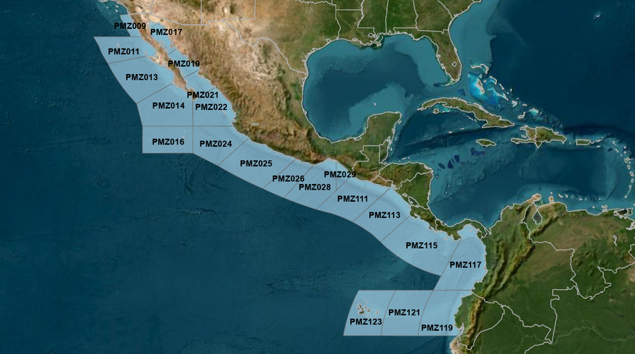
East Pacific within 250 nm of Mexico (OFFPZ7)
000
FZPN27 KNHC 092056
OFFPZ7

Offshore Waters Forecast
National Weather Service National Hurricane Center Miami, FL
156 PM PDT Thu May 9 2024

Offshore Waters Forecast for the E Pacific within 250 nm of
Mexico

Seas given as significant wave height, which is the average
height of the highest 1/3 of the waves. Individual waves may be
more than twice the significant wave height.
Synopsis for the E Pacific within 250 nm of Mexico
PMZ001-100900-
Synopsis for the E Pacific within 250 nm of Mexico
156 PM PDT Thu May 9 2024

.SYNOPSIS...High pressure N of the local area will shift south
and west while weakening through the weekend. This will maintain
moderate northwest winds offshore Baja California N of Cabo San
Lazaro, and moderate to fresh northwest winds S of Cabo San
Lazaro through the weekend. Winds could pulse to locally strong
south of Cabo San Lucas at night. Northwest swell will continue
to move into the Baja offshore waters through Fri, with seas in
excess of 8 ft persisting across the waters N through W of Punta
Eugenia today before subsiding overnight. Gentle to locally
moderate west to northwest winds along with moderate seas are
expected elsewhere across the S and southwestern Mexican offshore
waters through Mon night.
PMZ009 Zone Forecast
PMZ009-100900-
Mexico Border S to 30N within 60 nm of shore-
156 PM PDT Thu May 9 2024

.TONIGHT...Variable winds less than 5 kt N of 31N, and NW 10 kt
S of 31N. Seas 5 to 7 ft. Period 13 seconds.
.FRI...Variable winds less than 5 kt, becoming W to NW 10 kt in
the afternoon. Seas 4 to 6 ft. Period 13 seconds.
.FRI NIGHT...NW winds 10 kt. Seas 4 to 5 ft. Period 13 seconds.
.SAT...NW winds 10 kt. Seas 4 to 5 ft. Period 13 seconds.
.SAT NIGHT...NW winds 10 kt. Seas 4 to 5 ft. Period 18 seconds.
.SUN...W to NW winds 10 to 15 kt. Seas 4 ft. Period 17 seconds.
.SUN NIGHT...NW winds 10 to 15 kt. Seas 4 ft. Period 17 seconds.
.MON...W to NW winds 10 kt. Seas 4 ft. Period 16 seconds.
.MON NIGHT...NW winds 10 to 15 kt. Seas 4 ft. Period 16 seconds.
.TUE...NW winds 10 to 15 kt. Seas 4 to 5 ft. Period 15 seconds.
.TUE NIGHT...NW winds 10 to 15 kt. Seas 5 to 6 ft. Period
14 seconds.
Forecaster AKR
PMZ011 Zone Forecast
PMZ011-100900-
30N to Punta Eugenia within 250 nm of shore-
156 PM PDT Thu May 9 2024

.TONIGHT...NW winds 10 kt. Seas 6 to 8 ft. Period 13 seconds.
.FRI...NW winds 10 to 15 kt. Seas 5 to 7 ft. Period 12 seconds.
.FRI NIGHT...NW winds 10 to 15 kt. Seas 5 to 7 ft. Period
11 seconds.
.SAT...NW winds 10 to 15 kt. Seas 4 to 6 ft. Period 11 seconds.
.SAT NIGHT...NW winds 10 to 15 kt. Seas 4 to 6 ft. Period
12 seconds.
.SUN...NW winds 10 to 15 kt. Seas 4 to 5 ft. Period 12 seconds.
.SUN NIGHT...NW winds 10 to 15 kt. Seas 4 to 5 ft. Period
16 seconds.
.MON...NW winds 10 to 15 kt. Seas 4 to 5 ft. Period 16 seconds.
.MON NIGHT...NW winds 10 to 15 kt. Seas 4 ft. Period 15 seconds.
.TUE...NW winds 10 to 15 kt. Seas 4 to 5 ft. Period 15 seconds.
.TUE NIGHT...NW winds 10 to 15 kt. Seas 5 to 7 ft. Period
14 seconds.
Forecaster AKR
PMZ013 Zone Forecast
PMZ013-100900-
Punta Eugenia to Cabo San Lazaro within 250 nm offshore-
156 PM PDT Thu May 9 2024

.TONIGHT...NW to N winds 10 to 15 kt. Seas 6 to 8 ft. Period
14 seconds.
.FRI...NW to N winds 10 to 15 kt. Seas 6 to 7 ft. Period
13 seconds.
.FRI NIGHT...NW to N winds 10 to 15 kt. Seas 6 to 7 ft. Period
12 seconds.
.SAT...NW to N winds 10 to 15 kt. Seas 5 to 7 ft. Period
12 seconds.
.SAT NIGHT...NW to N winds 10 to 15 kt. Seas 5 to 6 ft. Period
17 seconds.
.SUN...NW winds 10 to 15 kt. Seas 5 to 6 ft. Period 17 seconds.
.SUN NIGHT...NW winds 10 to 15 kt. Seas 5 ft. Period 16 seconds.
.MON...NW winds 10 to 15 kt. Seas 4 to 5 ft. Period 16 seconds.
.MON NIGHT...NW winds 10 to 15 kt. Seas 4 to 5 ft. Period
15 seconds.
.TUE...NW winds 10 to 15 kt. Seas 4 to 5 ft. Period 15 seconds.
.TUE NIGHT...NW winds 10 to 15 kt. Seas 4 to 5 ft. Period
15 seconds.
Forecaster AKR
PMZ014 Zone Forecast
PMZ014-100900-
Cabo San Lazaro to Cabo San Lucas within 350 nm offshore N of
20N-
156 PM PDT Thu May 9 2024

.TONIGHT...NW to N winds 10 to 15 kt. Seas 6 to 7 ft. Period
14 seconds.
.FRI...NW to N winds 10 to 15 kt. Seas 6 to 8 ft. Period
14 seconds.
.FRI NIGHT...NW to N winds 15 to 20 kt. Seas 6 to 8 ft. Period
13 seconds.
.SAT...NW to N winds 15 kt. Seas 6 to 7 ft. Period 12 seconds.
.SAT NIGHT...NW to N winds 10 to 15 kt. Seas 6 to 7 ft. Period
16 seconds.
.SUN...NW to N winds 10 to 15 kt. Seas 5 to 6 ft. Period
16 seconds.
.SUN NIGHT...NW to N winds 10 to 15 kt. Seas 5 to 6 ft. Period
16 seconds.
.MON...NW to N winds 10 to 15 kt. Seas 5 to 6 ft. Period
15 seconds.
.MON NIGHT...NW to N winds 10 to 15 kt. Seas 5 ft. Period
15 seconds.
.TUE...NW to N winds 10 to 15 kt. Seas 4 to 5 ft. Period
15 seconds.
.TUE NIGHT...NW to N winds 10 to 15 kt. Seas 4 to 5 ft. Period
14 seconds.
Forecaster AKR
PMZ016 Zone Forecast
PMZ016-100900-
From 17N to 20N Between 110W and 115W including the
Revillagigedo Islands-
156 PM PDT Thu May 9 2024

.TONIGHT...N winds 10 to 15 kt. Seas 6 to 7 ft. Period
14 seconds.
.FRI...N winds 10 to 15 kt. Seas 6 to 7 ft. Period 14 seconds.
.FRI NIGHT...N winds 10 to 15 kt. Seas 7 to 8 ft. Period
13 seconds.
.SAT...N winds 10 to 15 kt. Seas 7 ft. Period 13 seconds.
.SAT NIGHT...N winds 10 to 15 kt. Seas 6 to 7 ft. Period
12 seconds.
.SUN...N to NE winds 10 to 15 kt. Seas 6 to 7 ft. Period
12 seconds.
.SUN NIGHT...N winds 10 kt. Seas 5 to 6 ft. Period 14 seconds.
.MON...N winds 10 to 15 kt. Seas 5 to 6 ft. Period 14 seconds.
.MON NIGHT...N winds 10 to 15 kt. Seas 5 to 6 ft. Period
14 seconds.
.TUE...N winds 10 to 15 kt. Seas 5 to 6 ft. Period 14 seconds.
.TUE NIGHT...N winds 10 to 15 kt. Seas 5 to 6 ft. Period
14 seconds.
Forecaster AKR
PMZ017 Zone Forecast
PMZ017-100900-
Northern Gulf of California-
156 PM PDT Thu May 9 2024

.TONIGHT...N of 30N, variable winds less than 5 kt. Elsewhere, W
winds 10 kt in the evening, becoming variable winds less than
5 kt. Seas 3 ft or less. Period 6 seconds.
.FRI...N of 30N, variable winds less than 5 kt. Elsewhere,
variable winds less than 5 kt, becoming N 10 kt in the
afternoon. Seas 3 ft or less. Period 6 seconds.
.FRI NIGHT...SW to W winds 10 kt. Seas 3 ft or less. Period
4 seconds.
.SAT...Variable winds less than 5 kt. Seas 3 ft or less. Period
3 seconds.
.SAT NIGHT...SW winds 10 kt. Seas 3 ft or less. Period
3 seconds.
.SUN...S winds 10 kt. Seas 3 ft or less. Period 3 seconds.
.SUN NIGHT...S winds 10 kt. Seas 3 ft or less. Period 3 seconds.
.MON...SE to S winds 10 kt. Seas 3 ft or less. Period 4 seconds.
.MON NIGHT...S to SW winds 10 to 15 kt. Seas 3 ft or less.
Period 4 seconds.
.TUE...S to SW winds 10 to 15 kt. Seas 3 ft or less. Period
5 seconds.
.TUE NIGHT...S to SW winds 10 to 15 kt. Seas 3 ft or less.
Period 4 seconds.
Forecaster AKR
PMZ019 Zone Forecast
PMZ019-100900-
Central Gulf of California-
156 PM PDT Thu May 9 2024

.TONIGHT...W to NW winds 10 kt. Seas 3 ft or less. Period
11 seconds.
.FRI...NW winds 10 to 15 kt. Seas 3 ft or less. Period
11 seconds.
.FRI NIGHT...W to NW winds 10 kt. Seas 3 ft or less. Period
11 seconds.
.SAT...NW winds 10 kt. Seas 3 ft or less. Period 10 seconds.
.SAT NIGHT...W to NW winds 10 kt. Seas 3 ft or less. Period
10 seconds.
.SUN...W winds 10 kt. Seas 3 ft or less. Period 10 seconds.
.SUN NIGHT...S to SW winds 10 kt. Seas 3 ft or less. Period
10 seconds.
.MON...SE to S winds 10 kt. Seas 3 ft or less. Period
11 seconds.
.MON NIGHT...SW to W winds 10 kt. Seas 3 ft or less. Period
13 seconds.
.TUE...SW winds 10 kt. Seas 3 ft or less. Period 14 seconds.
.TUE NIGHT...W winds 10 to 15 kt. Seas 3 ft or less. Period
14 seconds.
Forecaster AKR
PMZ021 Zone Forecast
PMZ021-100900-
Southern Gulf of California-
156 PM PDT Thu May 9 2024

.TONIGHT...NW winds 10 kt. Seas 3 ft or less. Period 13 seconds.
.FRI...NW winds 10 to 15 kt. Seas 3 ft or less. Period
13 seconds.
.FRI NIGHT...NW winds 10 to 15 kt. Seas 3 ft or less. Period
12 seconds.
.SAT...NW winds 10 kt. Seas 3 ft or less. Period 18 seconds.
.SAT NIGHT...W winds 10 kt. Seas 3 ft or less. Period
18 seconds.
.SUN...Variable winds less than 5 kt. Seas 3 ft or less. Period
17 seconds.
.SUN NIGHT...S to SW winds 10 kt. Seas 3 ft or less. Period
16 seconds.
.MON...Variable winds less than 5 kt. Seas 3 ft or less. Period
16 seconds.
.MON NIGHT...W winds 10 kt. Seas 3 ft or less. Period
15 seconds.
.TUE...W to NW winds 10 kt. Seas 3 ft or less. Period
15 seconds.
.TUE NIGHT...W winds 10 to 15 kt. Seas 3 ft or less. Period
14 seconds.
Forecaster AKR
PMZ022 Zone Forecast
PMZ022-100900-
N of 20N E of 110W to the Entrance of the Gulf of California-
156 PM PDT Thu May 9 2024

.TONIGHT...NW winds 10 to 15 kt. Seas 5 to 7 ft. Period
14 seconds.
.FRI...NW winds 10 to 15 kt. Seas 4 to 6 ft. Period 14 seconds.
.FRI NIGHT...W to NW winds 10 to 15 kt. Seas 5 to 7 ft. Period
16 seconds.
.SAT...W winds 10 kt. Seas 4 to 6 ft. Period 18 seconds.
.SAT NIGHT...SW to W winds 10 to 15 kt. Seas 4 to 6 ft. Period
18 seconds.
.SUN...S to SW winds 10 kt. Seas 4 to 6 ft. Period 17 seconds.
.SUN NIGHT...SW to W winds 10 kt. Seas 4 to 5 ft. Period
16 seconds.
.MON...SW to W winds 10 to 15 kt. Seas 4 to 5 ft. Period
16 seconds.
.MON NIGHT...NW winds 10 to 15 kt. Seas 4 to 5 ft. Period
15 seconds.
.TUE...NW winds 10 to 15 kt. Seas 4 to 6 ft. Period 15 seconds.
.TUE NIGHT...NW winds 10 to 15 kt. Seas 4 to 5 ft. Period
14 seconds.
Forecaster AKR
PMZ024 Zone Forecast
PMZ024-100900-
Colima and Jalisco within 300 nm offshore S of 20N and E of
110W-
156 PM PDT Thu May 9 2024

.TONIGHT...NW winds 10 to 15 kt. Seas 5 to 7 ft. Period
13 seconds.
.FRI...NW winds 10 to 15 kt. Seas 5 to 7 ft. Period 14 seconds.
.FRI NIGHT...N winds 10 to 15 kt. Seas 5 to 7 ft. Period
14 seconds.
.SAT...N winds 10 kt. Seas 5 to 7 ft. Period 17 seconds.
.SAT NIGHT...N to NE winds 10 kt. Seas 5 to 6 ft. Period
17 seconds.
.SUN...E to SE winds 10 kt N of 18N, and variable less than 5 kt
S of 18N. Seas 5 to 6 ft. Period 16 seconds.
.SUN NIGHT...NW winds 10 kt. Seas 5 to 6 ft. Period 16 seconds.
.MON...NW to N winds 10 kt. Seas 5 ft. Period 15 seconds.
.MON NIGHT...NW winds 10 to 15 kt. Seas 5 ft. Period 15 seconds.
.TUE...NW to N winds 10 kt. Seas 5 to 6 ft. Period 14 seconds.
.TUE NIGHT...NW winds 10 to 15 kt. Seas 5 to 6 ft. Period
14 seconds.
Forecaster AKR
PMZ025 Zone Forecast
PMZ025-100900-
Michoacan and Guerrero within 250 nm offshore-
156 PM PDT Thu May 9 2024

.TONIGHT...W to NW winds 10 kt in the evening, becoming variable
winds less than 5 kt. Seas 5 ft. Period 14 seconds.
.FRI...Variable winds less than 5 kt. Seas 4 to 6 ft. Period
14 seconds.
.FRI NIGHT...Within 60 nm of shore, variable winds less than
5 kt in the evening. Variable winds less than 5 kt late.
Elsewhere, W winds 10 kt in the evening. Seas 4 to
6 ft. Period 18 seconds.
.SAT...Variable winds less than 5 kt. Seas 5 to 6 ft. Period
18 seconds.
.SAT NIGHT...Variable winds less than 5 kt. Seas 5 to 6 ft.
Period 17 seconds.
.SUN...W winds 10 kt Within 60 nm of shore, and variable less
than 5 kt Elsewhere. Seas 5 to 6 ft. Period 17 seconds.
.SUN NIGHT...W winds 10 kt. Seas 5 ft. Period 16 seconds.
.MON...W to NW winds 10 kt. Seas 5 ft. Period 15 seconds.
.MON NIGHT...W to NW winds 10 kt. Seas 5 ft. Period 15 seconds.
.TUE...NW winds 10 kt. Seas 5 ft. Period 14 seconds.
.TUE NIGHT...W to NW winds 10 kt. Seas 4 to 5 ft. Period
14 seconds.
Forecaster AKR
PMZ026 Zone Forecast
PMZ026-100900-
Oaxaca W of Puerto Angel within 250 nm offshore-
156 PM PDT Thu May 9 2024

.TONIGHT...W winds 10 kt in the evening, becoming variable winds
less than 5 kt. Seas 5 ft. Period 14 seconds.
.FRI...N of 14N, variable winds less than 5 kt, becoming SW to W
10 kt in the afternoon. S of 14N, variable winds less than 5 kt.
Seas 4 to 5 ft. Period 14 seconds.
.FRI NIGHT...Variable winds less than 5 kt. Seas 4 to 5 ft.
Period 18 seconds.
.SAT...Variable winds less than 5 kt. Seas 4 to 5 ft. Period
18 seconds.
.SAT NIGHT...Variable winds less than 5 kt. Seas 5 ft. Period
17 seconds.
.SUN...W to NW winds 10 kt N of 14N, and variable less than 5 kt
S of 14N. Seas 5 ft. Period 17 seconds.
.SUN NIGHT...W to NW winds 10 kt N of 14N, and variable less
than 5 kt S of 14N. Seas 5 ft. Period 16 seconds.
.MON...NW winds 10 kt. Seas 5 ft. Period 15 seconds.
.MON NIGHT...W to NW winds 10 kt. Seas 5 ft. Period 15 seconds.
.TUE...NW winds 10 kt. Seas 5 ft. Period 14 seconds.
.TUE NIGHT...W to NW winds 10 kt N of 14N, and variable less
than 5 kt S of 14N. Seas 5 ft. Period 14 seconds.
Forecaster AKR
PMZ028 Zone Forecast
PMZ028-100900-
Oaxaca E of Puerto Angel within 300 nm offshore including the
Gulf of Tehuantepec-
156 PM PDT Thu May 9 2024

.TONIGHT...SW to W winds 10 kt N of 14N, and variable less than
5 kt S of 14N. Seas 4 to 5 ft. Period 14 seconds.
.FRI...N of 14N, SW winds 10 kt in the afternoon. Variable winds
less than 5 kt in the morning. S of 14N, variable winds less
than 5 kt. Seas 4 to 5 ft. Period 14 seconds.
.FRI NIGHT...W winds 10 kt N of 14N, and variable less than 5 kt
S of 14N. Seas 4 to 5 ft. Period 18 seconds.
.SAT...N of 14N, variable winds less than 5 kt, becoming SW to W
10 kt in the afternoon. S of 14N, variable winds less than 5 kt.
Seas 4 to 5 ft. Period 18 seconds.
.SAT NIGHT...SW to W winds 10 kt N of 14N, and variable less
than 5 kt S of 14N. Seas 5 ft. Period 17 seconds.
.SUN...SW to W winds 10 kt N of 14N, and variable less than 5 kt
S of 14N. Seas 4 to 5 ft. Period 17 seconds.
.SUN NIGHT...SW to W winds 10 kt N of 14N, and variable less
than 5 kt S of 14N. Seas 5 ft. Period 16 seconds.
.MON...SW to W winds 10 kt N of 14N, and variable less than 5 kt
S of 14N. Seas 5 ft. Period 15 seconds.
.MON NIGHT...SW to W winds 10 kt N of 14N, and variable less
than 5 kt S of 14N. Seas 5 ft. Period 15 seconds.
.TUE...SW to W winds 10 kt N of 14N, and variable less than 5 kt
S of 14N. Seas 4 to 5 ft. Period 14 seconds.
.TUE NIGHT...SW to W winds 10 kt N of 14N, and variable less
than 5 kt S of 14N. Seas 4 to 5 ft. Period 14 seconds.
Forecaster AKR
PMZ029 Zone Forecast
PMZ029-100900-
Offshore Chiapas E of 94W-
156 PM PDT Thu May 9 2024

.TONIGHT...Variable winds less than 5 kt. Seas 4 ft. Period
14 seconds.
.FRI...Variable winds less than 5 kt, becoming SW to W 10 kt in
the afternoon. Seas 4 ft. Period 14 seconds.
.FRI NIGHT...Variable winds less than 5 kt. Seas 4 ft. Period
17 seconds.
.SAT...Variable winds less than 5 kt, becoming W 10 kt in the
afternoon. Seas 4 ft. Period 18 seconds.
.SAT NIGHT...Variable winds less than 5 kt. Seas 4 to 5 ft.
Period 18 seconds.
.SUN...Variable winds less than 5 kt. Seas 4 to 5 ft. Period
17 seconds.
.SUN NIGHT...Variable winds less than 5 kt. Seas 4 to 5 ft.
Period 16 seconds.
.MON...Variable winds less than 5 kt. Seas 4 to 5 ft. Period
16 seconds.
.MON NIGHT...Variable winds less than 5 kt. Seas 4 to 5 ft.
Period 15 seconds.
.TUE...Variable winds less than 5 kt. Seas 4 ft. Period
15 seconds.
.TUE NIGHT...Variable winds less than 5 kt. Seas 4 ft. Period
14 seconds.
Forecaster AKR
East Pacific offshore of Central America, Colombia, & Ecuador (OFFPZ8)
000
FZPN28 KNHC 092057
OFFPZ8

Offshore Waters Forecast
NWS National Hurricane Center Miami, FL
157 PM PDT Thu May 9 2024

Offshore Waters Forecast for the E Pacific within 250 nm of
Central America, Colombia, and within 750 nm of Ecuador

Seas given as significant wave height, which is the average
height of the highest 1/3 of the waves. Individual waves may be
more than twice the significant wave height.
Synopsis for the E Pacific within 250 nm of Central America, Colombia, and within 750 nm of Ecuador
PMZ101-100900-
Synopsis for the E Pacific within 250 nm of Central America,
Colombia, and within 750 nm of Ecuador
157 PM PDT Thu May 9 2024

.SYNOPSIS...Moderate to locally fresh south to southwest winds
are expected S of 09N through Fri. This will feed moisture into
shower and thunderstorm activity currently over the Central
American waters. This activity will shift slowly westward of 90W
by Fri afternoon. Light to gentle variable winds will prevail
elsewhere along with moderate seas in a south swell. Otherwise,
new southerly swell entering the region will maintain seas of 6
to 7 ft S of the Galapagos Islands through Sun, and build briefly
to near 8 ft Fri night.
PMZ111 Zone Forecast
PMZ111-100900-
Guatemala and El Salvador to 250 nm offshore-
157 PM PDT Thu May 9 2024

.TONIGHT...Variable winds less than 5 kt. Seas 3 to 5 ft in S to
SW swell. Period 14 seconds.
.FRI...Variable winds less than 5 kt. Seas 3 to 5 ft in S to SW
swell. Period 14 seconds. Scattered showers through the day.
.FRI NIGHT...Variable winds less than 5 kt. Seas 3 to 5 ft in S
to SW swell. Period 17 seconds.
.SAT...Variable winds less than 5 kt. Seas 3 to 5 ft in S to SW
swell. Period 18 seconds.
.SAT NIGHT...Variable winds less than 5 kt. Seas 3 to 5 ft in S
to SW swell. Period 17 seconds.
.SUN...Variable winds less than 5 kt. Seas 3 to 5 ft in S to SW
swell. Period 16 seconds.
.SUN NIGHT...Variable winds less than 5 kt. Seas 3 to 5 ft in S
to SW swell. Period 15 seconds.
.MON...Variable winds less than 5 kt. Seas 3 to 5 ft in S to SW
swell. Period 14 seconds.
.MON NIGHT...Variable winds less than 5 kt. Seas 3 to 5 ft in S
to SW swell. Period 14 seconds.
.TUE...NE winds 10 kt. Seas 3 to 5 ft. Period 14 seconds.
.TUE NIGHT...Variable winds less than 5 kt. Seas 3 to 5 ft in S
to SW swell. Period 14 seconds.
Forecaster AKR
PMZ113 Zone Forecast
PMZ113-100900-
El Salvador to North Costa Rica including the Gulfs of Fonseca
and Papagayo-
157 PM PDT Thu May 9 2024

.TONIGHT...Offshore Gulf of Papagayo, SW winds 10 kt in the
evening, becoming variable winds less than 5 kt. Elsewhere,
variable winds less than 5 kt, becoming SW to W 10 kt late. Seas
3 to 5 ft in S swell. Period 15 seconds.
Scattered showers through the night.
.FRI...SW winds 10 kt. Seas 3 to 5 ft. Period 14 seconds.
Scattered showers through the day.
.FRI NIGHT...Offshore Gulf of Papagayo, S to SW winds 10 kt in
the evening, becoming variable winds less than 5 kt. Elsewhere,
SW to W winds 10 kt. Seas 3 to 5 ft. Period 18 seconds.
Scattered showers through the night.
.SAT...Offshore Gulf of Papagayo, S to SW winds 10 kt in the
afternoon. Variable winds less than 5 kt in the morning.
Elsewhere, variable winds less than 5 kt. Seas 3 to 5 ft. Period
18 seconds. Scattered showers through the day.
.SAT NIGHT...S to SW winds 10 kt. Seas 3 to 5 ft. Period
17 seconds.
.SUN...Variable winds less than 5 kt. Seas 3 to 5 ft in S swell.
Period 16 seconds.
.SUN NIGHT...S to SW winds 10 kt. Seas 3 to 5 ft. Period
15 seconds.
.MON...NE winds 10 kt. Seas 3 to 5 ft. Period 14 seconds.
.MON NIGHT...SW winds 10 kt. Seas 3 to 5 ft. Period 14 seconds.
.TUE...SE to S winds 10 kt. Seas 3 to 5 ft. Period 14 seconds.
.TUE NIGHT...S to SW winds 10 kt. Seas 3 to 5 ft. Period
14 seconds.
Forecaster AKR
PMZ115 Zone Forecast
PMZ115-100900-
North Costa Rica to West Panama to 250 nm offshore-
157 PM PDT Thu May 9 2024

.TONIGHT...Near the Azuero Peninsula, variable winds less than
5 kt. Variable winds less than 5 kt in the evening. Elsewhere,
SW winds 10 kt late. Seas 3 to 5 ft in S swell. Period
15 seconds. Scattered showers through the night.
.FRI...Variable winds less than 5 kt Near the Azuero Peninsula,
and SW 10 kt Elsewhere. Seas 4 to 6 ft in S swell. Period
14 seconds. Scattered showers and isolated tstms through the
day.
.FRI NIGHT...SW to W winds 10 kt. Seas 4 to 6 ft in S swell.
Period 14 seconds. Scattered tstms through the night.
.SAT...Variable winds less than 5 kt. Seas 4 to 6 ft in S swell.
Period 15 seconds. Scattered showers and isolated tstms through
the day.
.SAT NIGHT...Variable winds less than 5 kt. Seas 4 to 6 ft in S
swell. Period 15 seconds.
.SUN...Variable winds less than 5 kt. Seas 4 to 6 ft in S swell.
Period 14 seconds.
.SUN NIGHT...Variable winds less than 5 kt Near the Azuero
Peninsula, and SW 10 kt Elsewhere. Seas 4 to 6 ft in S swell.
Period 14 seconds.
.MON...Variable winds less than 5 kt Near the Azuero Peninsula,
and SW to W 10 kt Elsewhere. Seas 4 to 6 ft in S swell. Period
14 seconds.
.MON NIGHT...SW to W winds 10 kt. Seas 4 to 6 ft in S swell.
Period 14 seconds.
.TUE...Variable winds less than 5 kt Near the Azuero Peninsula,
and SW to W 10 kt Elsewhere. Seas 4 to 6 ft in S swell. Period
14 seconds.
.TUE NIGHT...SW to W winds 10 to 15 kt. Seas 4 to 6 ft. Period
13 seconds.
Forecaster AKR
PMZ117 Zone Forecast
PMZ117-100900-
East Panama and Colombia including the Gulf of Panama-
157 PM PDT Thu May 9 2024

.TONIGHT...Variable winds less than 5 kt. Seas 3 to 5 ft in S to
SW swell. Period 15 seconds.
.FRI...Gulf of Panama, variable winds less than 5 kt. Elsewhere,
SE to S winds 10 kt, shifting to SW to W in the afternoon. Seas
4 to 6 ft in S to SW swell. Period 14 seconds.
.FRI NIGHT...SW winds 10 to 15 kt. Seas 4 to 6 ft. Period
18 seconds. Scattered showers through the night.
.SAT...SW to W winds 10 kt. Seas 4 to 6 ft in S to SW swell.
Period 18 seconds.
.SAT NIGHT...Variable winds less than 5 kt. Seas 4 to 6 ft in S
to SW swell. Period 17 seconds.
.SUN...Variable winds less than 5 kt Gulf of Panama, and SW to W
10 kt Elsewhere. Seas 4 to 6 ft in S to SW swell. Period
16 seconds.
.SUN NIGHT...Variable winds less than 5 kt Gulf of Panama, and
SW to W 10 kt Elsewhere. Seas 4 to 6 ft in S to SW swell. Period
16 seconds.
.MON...SW to W winds 10 to 15 kt. Seas 4 to 6 ft. Period
15 seconds.
.MON NIGHT...SW to W winds 10 to 15 kt. Seas 4 to 6 ft. Period
14 seconds.
.TUE...SW winds 10 to 15 kt. Seas 4 to 6 ft. Period 14 seconds.
.TUE NIGHT...SW winds 10 to 15 kt. Seas 4 to 6 ft. Period
13 seconds.
Forecaster AKR
PMZ119 Zone Forecast
PMZ119-100900-
Ecuador including the Gulf of Guayaquil to 250 nm offshore-
157 PM PDT Thu May 9 2024

.TONIGHT...SW winds 10 kt. Seas 4 to 6 ft in S to SW swell.
Period 14 seconds.
.FRI...S to SW winds 10 to 15 kt. Seas 5 to 7 ft in S to SW
swell. Period 14 seconds.
.FRI NIGHT...Gulf of Guayaquil, SW to W winds 10 kt in the
evening, becoming variable winds less than 5 kt. Elsewhere, S to
SW winds 10 to 15 kt. Seas 5 to 7 ft in S to SW swell. Period
18 seconds.
.SAT...Gulf of Guayaquil, variable winds less than 5 kt,
becoming W 10 kt in the afternoon. Elsewhere, S to SW winds
10 kt. Seas 5 to 7 ft in S to SW swell. Period 17 seconds.
.SAT NIGHT...SW winds 10 to 15 kt. Seas 5 to 7 ft in S to SW
swell. Period 15 seconds.
.SUN...S to SW winds 10 to 15 kt. Seas 4 to 6 ft. Period
15 seconds.
.SUN NIGHT...S to SW winds 10 to 15 kt. Seas 4 to 6 ft. Period
15 seconds.
.MON...S to SW winds 10 to 15 kt. Seas 4 to 6 ft. Period
14 seconds.
.MON NIGHT...S to SW winds 10 to 15 kt. Seas 4 to 6 ft. Period
14 seconds.
.TUE...S to SW winds 10 to 15 kt. Seas 4 to 6 ft. Period
13 seconds.
.TUE NIGHT...S to SW winds 10 to 15 kt. Seas 4 to 6 ft. Period
12 seconds.
Forecaster AKR
PMZ121 Zone Forecast
PMZ121-100900-
Ecuador between 250 and 500 nm offshore-
157 PM PDT Thu May 9 2024

.TONIGHT...SE to S winds 10 kt. Seas 4 to 6 ft in S swell.
Period 14 seconds.
.FRI...S winds 10 to 15 kt. Seas 4 to 6 ft. Period 15 seconds.
.FRI NIGHT...SE to S winds 10 to 15 kt. Seas 5 to 7 ft in S
swell. Period 17 seconds.
.SAT...SE to S winds 10 kt. Seas 5 to 7 ft in S swell. Period
17 seconds.
.SAT NIGHT...SE to S winds 10 kt. Seas 5 to 7 ft in S swell.
Period 14 seconds.
.SUN...SE to S winds 10 to 15 kt. Seas 5 to 7 ft in S swell.
Period 15 seconds.
.SUN NIGHT...S winds 10 kt. Seas 4 to 6 ft in S swell. Period
14 seconds.
.MON...SE to S winds 10 to 15 kt. Seas 4 to 6 ft. Period
14 seconds.
.MON NIGHT...SE to S winds 10 kt. Seas 4 to 6 ft in S swell.
Period 13 seconds.
.TUE...SE to S winds 10 kt. Seas 4 to 6 ft in S swell. Period
13 seconds.
.TUE NIGHT...S winds 10 to 15 kt. Seas 4 to 6 ft. Period
11 seconds.
Forecaster AKR
PMZ123 Zone Forecast
PMZ123-100900-
Offshore Galapagos Islands-
157 PM PDT Thu May 9 2024

.TONIGHT...SE to S winds 10 kt. Seas 5 to 7 ft in S swell.
Period 16 seconds.
.FRI...SE winds 10 kt. Seas 5 to 7 ft in S swell. Period
18 seconds.
.FRI NIGHT...SE winds 10 to 15 kt. Seas 5 to 7 ft in S swell.
Period 17 seconds.
.SAT...SE winds 10 kt. Seas 5 to 7 ft in S swell. Period
17 seconds.
.SAT NIGHT...SE winds 10 kt. Seas 5 to 7 ft in S swell. Period
14 seconds.
.SUN...SE winds 10 kt. Seas 5 to 7 ft in S swell. Period
12 seconds.
.SUN NIGHT...SE to S winds 10 kt. Seas 5 to 7 ft in S swell.
Period 12 seconds.
.MON...SE to S winds 10 kt. Seas 5 to 7 ft in S swell. Period
12 seconds.
.MON NIGHT...SE to S winds 10 kt. Seas 5 to 7 ft in S swell.
Period 12 seconds.
.TUE...SE to S winds 10 kt. Seas 4 to 6 ft in S swell. Period
11 seconds.
.TUE NIGHT...S winds 10 kt. Seas 4 to 6 ft in S swell. Period
11 seconds.
Forecaster AKR
Tropical North Atlantic High Seas (HSFAT2)
000
FZNT02 KNHC 092018
HSFAT2

HIGH SEAS FORECAST
NWS NATIONAL HURRICANE CENTER MIAMI FL
2230 UTC THU MAY 9 2024

SUPERSEDED BY NEXT ISSUANCE IN 6 HOURS

SEAS GIVEN AS SIGNIFICANT WAVE HEIGHT...WHICH IS THE AVERAGE
HEIGHT OF THE HIGHEST 1/3 OF THE WAVES. INDIVIDUAL WAVES MAY BE
MORE THAN TWICE THE SIGNIFICANT WAVE HEIGHT.

SECURITE

ATLANTIC FROM 07N TO 31N W OF 35W INCLUDING CARIBBEAN SEA AND
GULF OF MEXICO

SYNOPSIS VALID 1800 UTC THU MAY 9.
24 HOUR FORECAST VALID 1800 UTC FRI MAY 10.
48 HOUR FORECAST VALID 1800 UTC SAT MAY 11.

.WARNINGS.

.NONE.

.SYNOPSIS AND FORECAST.

.ATLC WITHIN 22N35W TO 22N47W TO 18N47W TO 17N39W TO 17N35W TO
22N35W WINDS 20 KT OR LESS. SEAS 8 FT IN N SWELL.
.24 HOUR FORECAST WITHIN 18N35W TO 17N38W TO 12N38W TO 12N35W TO
18N35W WINDS 20 KT OR LESS. SEAS 8 FT IN N SWELL.
.36 HOUR FORECAST CONDITIONS IMPROVE. WINDS 20 KT OR LESS. SEAS
LESS THAN 8 FT.

.ATLC 36 HOUR FORECAST COLD FRONT FROM 31N75W TO 28N80W. WITHIN
31N67W TO 31N78W TO 29N77W TO 28N75W TO 29N73W TO 31N67W SW WINDS
20 TO 25 KT. SEAS 8 FT.
.48 HOUR FORECAST COLD FRONT FROM 31N72W TO 27N80W. WITHIN
31N65W TO 31N73W TO 28N74W TO 27N73W TO 29N69W TO 31N65W SW TO W
WINDS 20 TO 25 KT. SEAS 8 TO 10 FT IN W SWELL.

.CARIBBEAN 06 HOUR FORECAST WITHIN 17N85W TO 19N87W TO 18N88W TO
16N89W TO 16N87W TO 16N84W TO 17N85W...INCLUDING THE GULF OF
HONDURAS... E WINDS 20 TO 25 KT. SEAS LESS THAN 8 FT.
.24 HOUR FORECAST LITTLE CHANGE.
.48 HOUR FORECAST LITTLE CHANGE.

.REMAINDER OF AREA WINDS 20 KT OR LESS. SEAS LESS THAN 8 FT.

$$
.FORECASTER CHRISTENSEN. NATIONAL HURRICANE CENTER.
Tropical Northeast Pacific High Seas (HSFEP2)
238
FZPN03 KNHC 092058
HSFEP2

HIGH SEAS FORECAST
NWS NATIONAL HURRICANE CENTER MIAMI FL
2230 UTC THU MAY 9 2024

SUPERSEDED BY NEXT ISSUANCE IN 6 HOURS

SEAS GIVEN AS SIGNIFICANT WAVE HEIGHT...WHICH IS THE AVERAGE
HEIGHT OF THE HIGHEST 1/3 OF THE WAVES. INDIVIDUAL WAVES MAY BE
MORE THAN TWICE THE SIGNIFICANT WAVE HEIGHT.

SECURITE

E PACIFIC FROM THE EQUATOR TO 30N E OF 140W AND 03.4S TO THE
EQUATOR E OF 120W

SYNOPSIS VALID 1800 UTC THU MAY 9.
24 HOUR FORECAST VALID 1800 UTC FRI MAY 10.
48 HOUR FORECAST VALID 1800 UTC SAT MAY 11.

.WARNINGS.

.NONE.

.SYNOPSIS AND FORECAST.

.WITHIN 30N117W TO 30N133W TO 25N127W TO 24N123W TO 26N116W TO
30N117W...INCLUDING SEBASTIAN VIZCAINO BAY...WINDS 20 KT OR
LESS. SEAS 8 TO 9 FT IN NW SWELL.
.18 HOUR FORECAST CONDITIONS IMPROVE. WINDS 20 KT OR LESS. SEAS
LESS THAN 8 FT.

.WITHIN 15N133W TO 17N137W TO 18N140W TO 10N140W TO 10N137W TO
12N135W TO 15N133W WINDS 20 KT OR LESS. SEAS 8 FT IN NE TO E
SWELL.
.24 HOUR FORECAST WITHIN 13N130W TO 15N135W TO 15N140W TO
11N140W TO 11N132W TO 13N130W WINDS 20 KT OR LESS. SEAS 8 FT IN
NE TO E SWELL.
.42 HOUR FORECAST CONDITIONS IMPROVE. WINDS 20 KT OR LESS. SEAS
LESS THAN 8 FT.

.REMAINDER OF AREA WINDS 20 KT OR LESS. SEAS LESS THAN 8 FT.

CONVECTION VALID AT 2030 UTC THU MAY 9...

.INTERTROPICAL CONVERGENCE ZONE/MONSOON TROUGH...
MONSOON TROUGH EXTENDS FROM 09N84W TO 08N105W TO LOW PRES NEAR
10N117W 1011 MB. ITCZ EXTENDS FROM 10N117W TO 06N130W TO BEYOND
05N140W. SCATTERED MODERATE TO STRONG FROM 05N TO 13N BETWEEN
96W AND 111W. SCATTERED MODERATE FROM 07N TO 13N BETWEEN 84W AND
91W.

$$
.FORECASTER AREINHART. NATIONAL HURRICANE CENTER.