000
AXNT20 KNHC 121102
TWDAT
Tropical Weather Discussion
NWS National Hurricane Center Miami FL
1205 UTC Sun May 12 2024
Tropical Weather Discussion for North America, Central America
Gulf of Mexico, Caribbean Sea, northern sections of South
America, and Atlantic Ocean to the African coast from the
Equator to 31N. The following information is based on satellite
imagery, weather observations, radar and meteorological analysis.
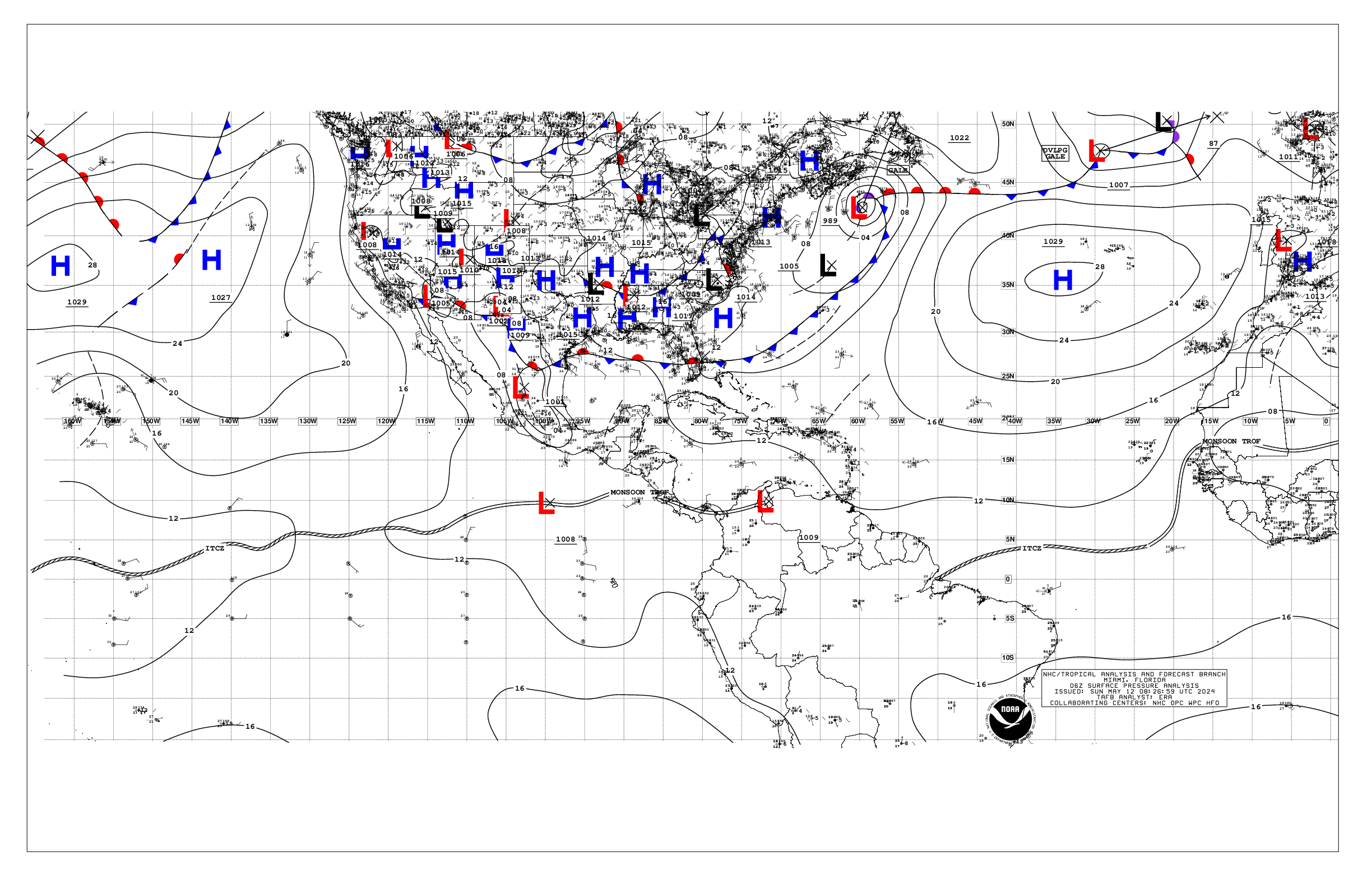
Based on 0600 UTC surface analysis and satellite imagery through
1045 UTC.
...MONSOON TROUGH/ITCZ...
The monsoon trough axis extends passes off the coast of Africa
near 14N17W and continues southwestward to 07N23W, where overnight
scatterometer data indicates that it transitions to the ITCZ and
continues to 04N30W to 02N40W and to near 00N48W. Scattered
moderate to isolated strong convection is within 60 nm north
of the ITCZ between 26W-30W. Scattered moderate convection is
seen within 120 nm north of the ITCZ between 32W-35W and
within 60 nm north of the ITCZ between 37W-40W. Similar convection
is from 01N to 04N between 45W and the coast of Brazil.
...GULF OF MEXICO...
A stationary front extends from near Fort Myers, Florida to the
central Gulf near 27N90W and to inland Texas near Corpus Christi.
A mid-level shortwave trough lifting northeastward over
southeastern Texas is acting on the stationary boundary leading to
the development of scattered showers and thunderstorms over the
waters within about 120 nm east of South Texas and northeastern
Mexico. This activity is quickly moving east-northeastward.
Isolated showers and thunderstorms are elsewhere north of 26N and
west of 93W. The remainder of the basin is under a weak pressure
pattern, typical for this time of year. Fresh easterly winds and
seas of 3-4 ft are occurring off the Yucatan Peninsula. Mostly
moderate east to southeast winds and seas of 4 to 5 ft are north
of 27N and west of 90W. Gentle to moderate easterly winds and 2-4
ft seas are over the rest of the western half of the Gulf of
Mexico. Elsewhere, light to gentle winds and slight seas prevail.
For the forecast, the eastern portion of the front will slowly
move southeastward and extend from the Straits of Florida to the
central Gulf this morning, where it will stall again and weaken
with its remnants lifting back N as a warm front through Sun
night. Moderate to fresh return flow will dominate for the end of
the weekend into early next week, with another front or trough
possibly impacting the western Gulf Mon night. High pressure
should rebuild across the basin mid-week, with moderate to fresh
SE-S winds, locally strong. Meanwhile, haze due to agricultural
fires in Mexico continues across most of the western Gulf and Bay
of Campeche. Fresh to strong winds will pulse near the Yucatan
Peninsula each evening through the period.
...CARIBBEAN SEA...
A weak pressure gradient prevails across the Caribbean and
maintains moderate trade winds over most of the basin. The
exception is the Gulf of Honduras, where fresh to strong east to
southeast winds remain rather persistent there as seen in an
overnight ASCAT pass. Seas are slight to moderate across the
basin, with peak seas to 6 ft in the Gulf of Honduras.
Rather stable atmospheric conditions under a broad anticyclone
aloft prevail across most of the basin west of 75W, except in
the far southwestern part of the basin where scattered showers
and thunderstorms are noted and in the far northeast part of the
basin, where lingering moisture is evident along with some
degree of atmospheric instability present there. The eastern
segment of the east Pacific monsoon trough reaches eastward into
the southwestern Caribbean and into northern Colombia helping to
sustain the aforementioned shower and thunderstorm activity.
Isolated showers are over some sections of the eastern Caribbean.
This activity may increase to that of the scattered type today
over some areas, including islands, of the northeast part of the
basin as mid to upper-level atmospheric conditions become more
favorable for the enhancement of convective activity.
For the forecast, high pressure over the central Atlantic will
support strong to near gale east to southeast winds near the Gulf
of Honduras, moderate to fresh winds in the south-central and in
the southeastern Caribbean, with gentle to moderate winds
elsewhere into the upcoming week. The pressure gradient will
tighten early next week, with fresh to strong trade winds expected
in the south-central and in the northwestern Caribbean, and
moderate to fresh trade winds elsewhere. Seas will build next week
as a result of the increasing winds. Meanwhile, haze due to
agricultural fires in Central America continues across some areas
of the northwestern Caribbean.
...ATLANTIC OCEAN...
A cold front is analyzed from 31N67W to 27N73W and to the
northern Bahamas, where it transitions to a stationary front
to inland South Florida near Palm Beach. A pre-frontal trough
extends from 31N65W to 26N72W. Satellite imagery shows scattered
showers and isolated thunderstorms from 26N to 29N between the
trough and 66W. Moderate to fresh southwest winds are east of the
front to 60W and north of 27N. Seas with these winds are 5 to 7
ft. To the southeast of the trough, another trough is analyzed
from 24N60W to the Mona Passage. Isolated showers are along and
near the trough. Scattered showers and thunderstorms moving
quickly eastward are noted from 20N to 24N between 57W and 61W.
Mostly gentle east to southeast winds are east of this trough to
near 59W. Another area of scattered showers and thunderstorms
that is moving eastward at a pretty fast pace is to the north,
from 24N to 31N between 54W and 57W. Both areas of shower and
thunderstorm activity are underneath upper-level diffluence found
on the SE side of a broad mid-upper level trough that covers a
good portion of the western Atlantic.
The remainder of the basin is dominated by a broad 1029 mb high
pressure system centered to the southwest of the Azores. The
pressure gradient between this ridge and relatively lower
pressures in northwest Africa result in fresh to strong northerly
winds north of 15N and east of about 30W, with the strongest
winds off Morocco. Seas in the area described are in the 6 to 8 ft
range. Elsewhere, moderate or weaker winds and moderate seas are
prevalent.
For the forecast W of 55W, the aforementioned cold front will
reach from near 31N64W to vicinity of the Florida Keys by early
this afternoon, then from 31N59W to the central Bahamas early
Mon, dissipating from 28N55W to 23N70W early Tue. High pressure
will build in behind the front for the start of next week. Fresh
to strong southerly winds and building seas are forecast offshore
N Florida by mid-week ahead of another possible cold front. That
front may reach from near 31N76W to 27N80W by early Thu.
$$
Aguirre


