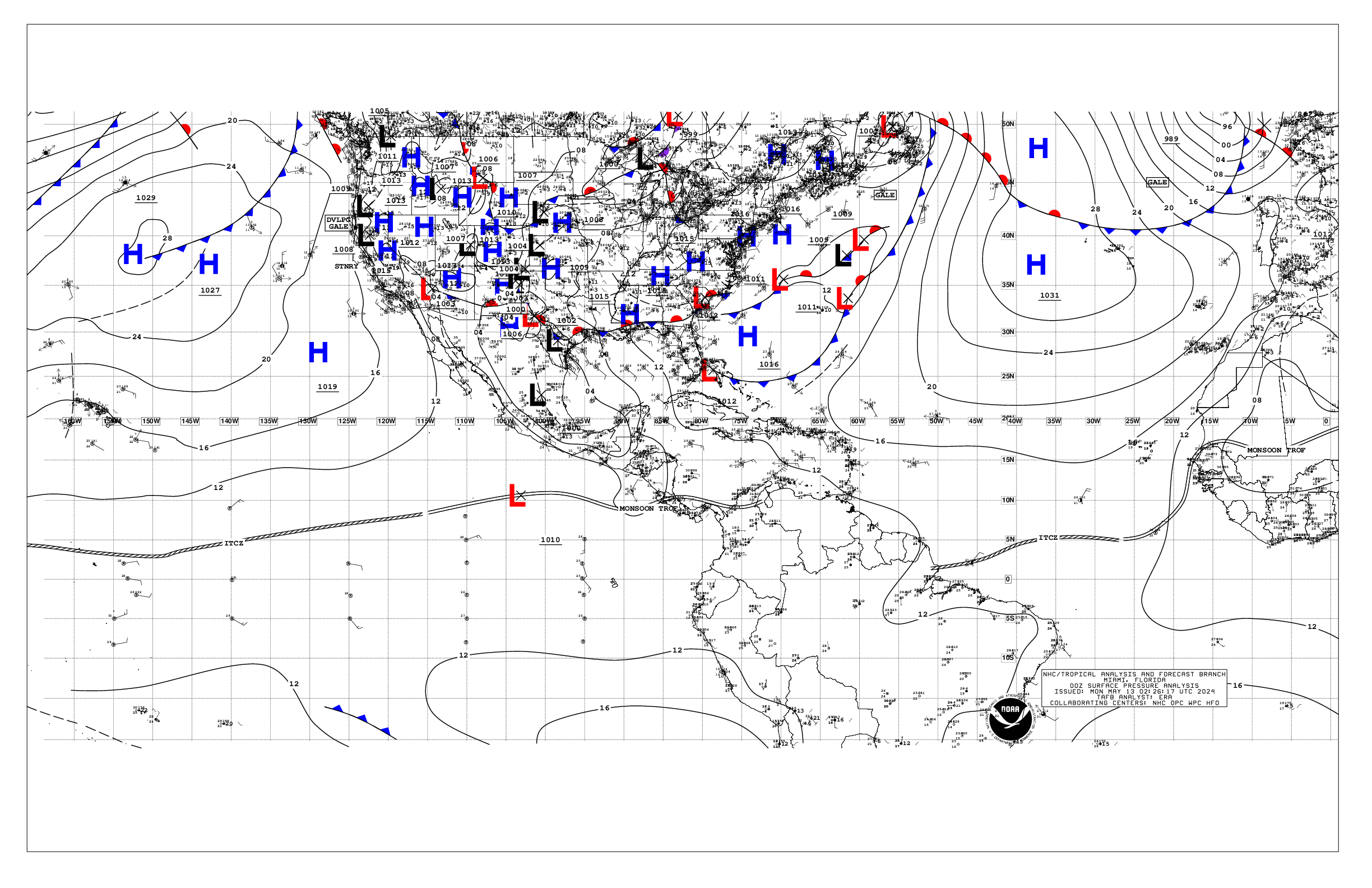
743
AXNT20 KNHC 120516
TWDAT

Tropical Weather Discussion
NWS National Hurricane Center Miami FL
0605 UTC Sun May 12 2024

Tropical Weather Discussion for North America, Central America
Gulf of Mexico, Caribbean Sea, northern sections of South
America, and Atlantic Ocean to the African coast from the
Equator to 31N. The following information is based on satellite
imagery, weather observations, radar and meteorological analysis.

Based on 0000 UTC surface analysis and satellite imagery through
0500 UTC.

...MONSOON TROUGH/ITCZ...

The monsoon trough extends from the coast of Africa near 13N17W
south-southwestward to 07N22W. The ITCZ continues from 07N22W to
00N47W. Scattered moderate convection is noted along the ITCZ.

...GULF OF MEXICO...

A stationary front extends across the northern portion of the
basin from 27N82W to 28N97W. No deep convection is noted near
this boundary. The remainder of the basin is dominated by a weak
high pressure system over the southern United States. Fresh to
strong easterly winds and seas of 3-4 ft are occurring off
Yucatan. Moderate to fresh easterly winds and 2-4 ft seas are
evident in the rest of the western half of the Gulf of Mexico.
Elsewhere, light to gentle winds and slight seas prevail.

For the forecast, moderate to fresh NE winds follow the
stationary front W of 90W. The eastern portion of the front will
drift SE and reach from the Straits of Florida to the central
Gulf by early Sun where it will stall again and weaken, with its
remnants lifting back N as a warm front through Sun night.
Moderate to fresh return flow will dominate for the end of the
weekend into early next week, with another front or trough
possibly impacting the western Gulf Mon night. High pressure
should rebuild across the basin mid-week, with moderate to fresh
SE-S winds, locally strong. Meanwhile, haze due to agricultural
fires in Mexico continues across most of the western Gulf and Bay
of Campeche. Fresh to strong winds will pulse near the Yucatan
Peninsula each evening through the period.

...CARIBBEAN SEA...

A weak pressure gradient prevails across the Caribbean and
maintains moderate trade winds over most of the basin. The
exception is the Gulf of Honduras, where fresh to strong east to
southeast winds are present. Seas are slight to moderate across
the basin, with peak seas to 6 ft in the Gulf of Honduras.

Stable atmospheric conditions under a broad anticyclone aloft
prevail across most of the basin west of 75W, except in the far
southwestern part of the basin where scattered showers are noted.
This is where the eastern segment of the east Pacific monsoon
trough exists.

For the forecast, high pressure N of the basin will support fresh
to strong winds near the Gulf of Honduras, moderate to fresh
winds in the south-central and in the southeastern Caribbean, with
gentle to moderate winds elsewhere through the remainder of the
weekend. The pressure gradient will tighten early next week, with
fresh to strong trades in the south-central and northwestern
Caribbean, and moderate to fresh elsewhere. Seas will build next
week as a result of the increasing winds. Meanwhile, haze due to
agricultural fires in Central America continues across much of the
NW Caribbean.

...ATLANTIC OCEAN...

A cold front extends from 31N70W to 27N80W. A pre-frontal trough
is analyzed from 31N66W to 27N74W. Scattered showers are noted
along the trough. Moderate to fresh SW winds are found N of 27N
and ahead of the front to 60W. Seas in these waters are 5-8 ft. To
the SE, another trough is analyzed from 24N60W to 19N67W with
scattered showers. Fresh winds are noted within 60 nm on either
side of the trough with seas to 4 ft.

The remainder of the basin is dominated by a broad 1029 mb high
pressure system centered SW of the Azores. The pressure gradient
between this ridge and lower pressures in NW Africa result in
fresh to strong northerly winds north of 15N and east of 30W,
with the strongest winds off Morocco. Seas in the area described
are 6-8 ft. Elsewhere, moderate or weaker winds and moderate seas
are prevalent.

For the forecast W of 55W, the cold front will reach from near
31N64W to vicinity of the Florida Keys early Sun, then from 31N59W
to the central Bahamas early Mon, dissipating from 28N55W to
23N70W early Tue. High pressure will build in behind the front for
the start of next week. Fresh to strong southerly winds and
building seas are forecast offshore N Florida by mid-week ahead of
another possible cold front. That front may reach from near
31N76W to 27N80W by early Thu.

$$
ERA
Alternate Formats
About Alternates -
E-Mail Advisories -
RSS Feeds
Cyclone Forecasts
Latest Advisory -
Past Advisories -
About Advisories
Marine Forecasts
Latest Products -
About Marine Products
Tools & Data
Satellite Imagery -
US Weather Radar -
Aircraft Recon -
Local Data Archive -
Forecast Verification -
Deadliest/Costliest/Most Intense
Learn About Hurricanes
Storm Names
Wind Scale -
Prepare -
Climatology -
NHC Glossary -
NHC Acronyms -
Frequently Asked Questions -
AOML Hurricane-Research Division
About Us
About NHC -
Mission/Vision -
Other NCEP Centers -
NHC Staff -
Visitor Information -
NHC Library
NOAA/
National Weather Service
National Centers for Environmental Prediction
National Hurricane Center
11691 SW 17th Street
Miami, Florida, 33165-2149 USA
nhcwebmaster@noaa.gov
Disclaimer
Privacy Policy
Credits
About Us
Glossary
Career Opportunities
Page last modified: Sunday, 12-May-2024 05:16:11 UTC